Lincoln Drive Neighborhood (now Lincoln Drive Park)
Introduction
Text-to-speech Audio
When the Red River Flood of 1997 hit Grand Forks and East Grand Forks, there is no question about the sheer extent of damage both cities underwent, especially their downtown areas and neighborhoods near the river. Among these, Lincoln Drive Neighborhood was one of the first places in Grand Forks to flood, due to its location nestled at a bend in the Red River. A working-class neighborhood and home to Lincoln Elementary School, Lincoln Drive Neighborhood was decimated in the flood’s aftermath. Today, the area is home to a prominent park of Grand Forks’ Greenway, built upon the bones of the old neighborhood to prevent flood waters from ever wreaking such destruction ever again.
Images
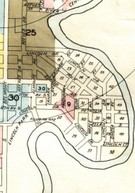
Lincoln Drive Neighborhood in 1927 as shown in Sanborn Map
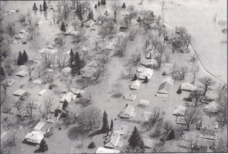
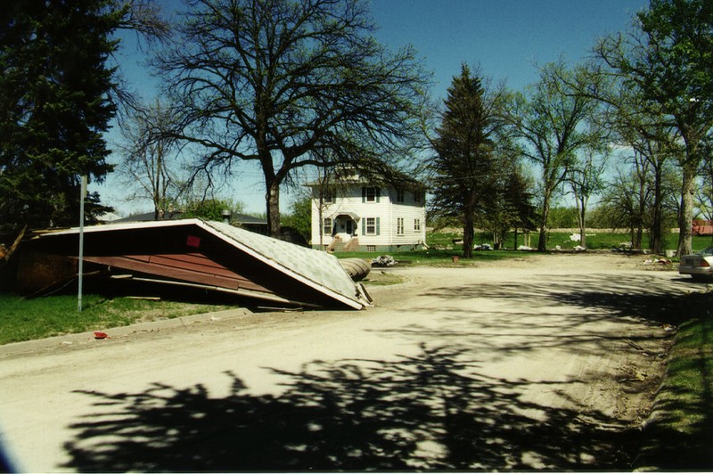
The disaster begins to unfold in Grand Forks
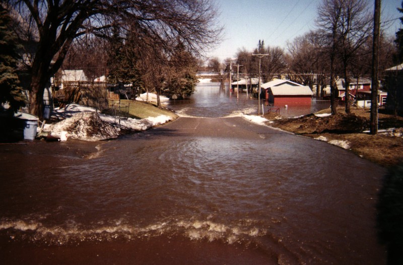
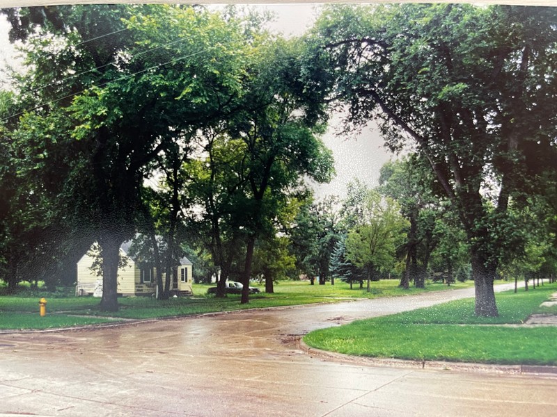
Lanark Street in Lincoln Drive Park. Now the road that leads to the dog parks
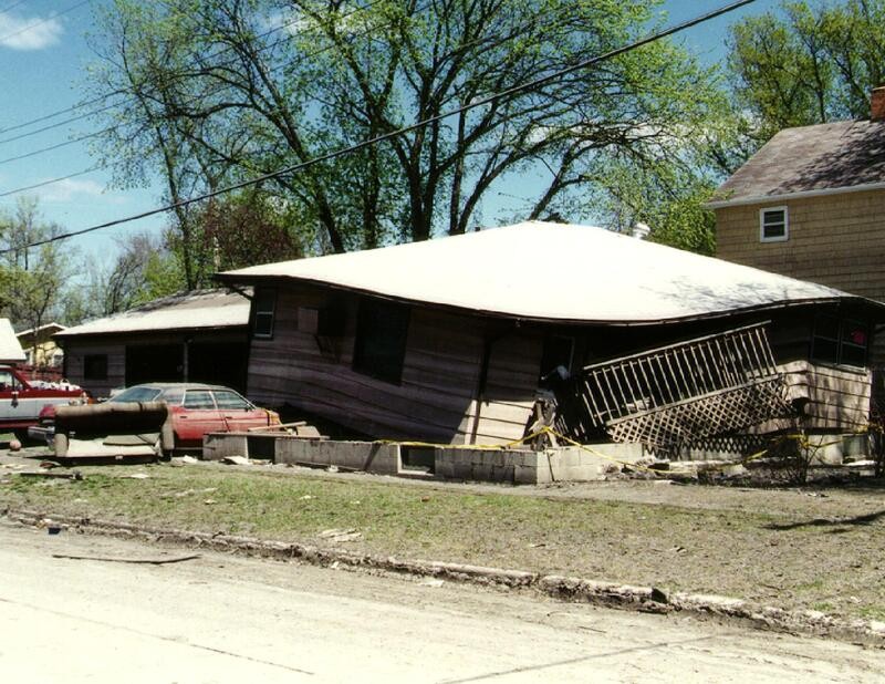
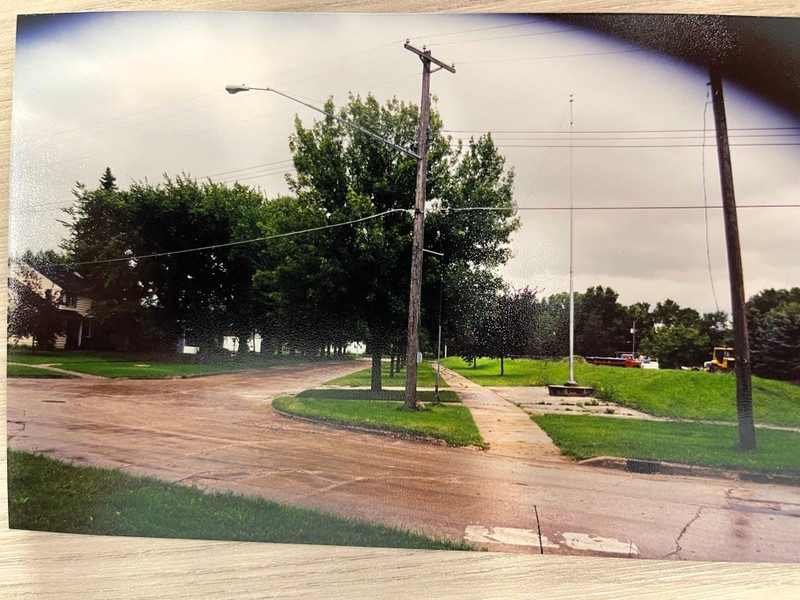
Corner of Lanark & Lincoln Drive in Lincoln Drive Park. Current site of the dog park
Omega Avenue in Lincoln Drive Park (now basket #7 of The Loop disc golf course).
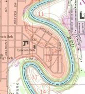
Lincoln Drive Neighborhood as shown in 1963 in USGS Map
Kelly Straub’s House on Maple St. in Lincoln Drive Area
Temporary Dike build on Lincoln School Site
Backstory and Context
Text-to-speech Audio
The Lincoln Drive Neighborhood (sometimes called the Lincoln Park Neighborhood) was a prominent working-class neighborhood that stood in Grand Forks since at least 1923, according to Sanborn maps of the city.[1] Over the decades, some of the streets of the neighborhood were apparently consolidated so that the neighborhood would instead have longer avenues with connecting streets near the ends.[2] Lincoln Drive Neighborhood was one of, if not the first areas of Grand Forks to flood.[3] In some ways only photographs can capture the true extent of the flooding, with houses submerged in their entirety as shown by the image “The disaster begins to unfold in Grand Forks.”[4] Despite the unfortunate loss of dozens of residents’ complete loss of homes and belongings, the land that the Lincoln Drive Neighborhood was built on has been effectively put to use as a Greenway, promoting outdoor recreation while protecting from future flood.
While the end result was a flooded and destroyed neighborhood, Lincoln Drive residents, Grand Forks residents, and UND officials worked tirelessly to construct, maintain, and rebuild broken levees and dikes.[5] Residents likely even watched as the neighborhood slowly filled with water[6] (see: “Lanark Street in Lincoln Drive Park. Now the road that leads to the dog parks.”). However, by April 18th residents of the neighborhood, like many others throughout the city, were ordered to evacuate.[7] Once the flood waters had receded and the city of Grand Forks was safe to inhabit again, Lincoln Drive residents were able to see the damage themselves. With road and debris alike caked in mud, an entire house lifted, warped, and deposited on top of a resident’s car[8] (see: “Corner of Lanark & Lincoln Drive in Lincoln Drive Park. Current site of the dog park.”) it was clear to many returning residents that they would have to start over.
In the aftermath of the flood, the Grand Forks City government acted with the U.S. Army Corps of Engineers to recover the city from the devastation.[9] For instance, the image “Temporary Dike built on Lincoln School Site” shows a small dike being built where the old Lincoln Elementary School had used to be.[10] It is possible that this small dike still exists in Lincoln Park today, according to the landscape of Lincoln Park as seen through Google Maps.
As part of the recovery and rebuilding process, the City of Grand Forks instituted a property buy-out program for residents and business owners in flooded neighborhoods, such as Lincoln Drive. While many residents surely accepted the buy-back as soon as possible to get back on their feet, one Lincoln Drive resident gained local notoriety for holding out for a fairer value[11]. Seen in Draves’ “Kelly Straub’s House on Maple St. in Lincoln Drive Area”, Straub’s house was essentially the only home left in her area of the neighborhood by 1999.[12] After waiting for the City to officially use eminent domain, Straub was able to use federal law to enforce a buy-out for the price of her new home where she housed her family.[13]
The plan to rebuild Grand Forks consisted of the construction of new dikes, floodwalls, and water pumps to protect the city. At the same time, the City saw an opportunity to use the bulldozed green land to construct a “Greenway” along the wet side of the floodwalls. This Greenway would serve as outdoor recreation space, spanning the length of Grand Forks and the Red River.[14] Today in Lincoln Drive Park, there stands a playground, a dog park, a disc golf course, and ample green space for recreation and play.
With the Flood of 1997, much of the history of the Lincoln Drive neighborhood was lost. Much of the research and documentation about Lincoln Drive has been exclusively focused on the flood. While this is understandable how the Flood is somewhat engrained into the cultural memory of Grand Forks, it is regrettable that this long-standing neighborhood so near to the heart of the city has so little information about it.
The havoc and destruction of the Lincoln Drive Neighborhood, and of Grand Forks as whole, was a terrible and tragic event. The sacrifice that many Grand Forks residents were forced to make cost them their belongings, their homes, and their lifestyles as they knew them. From the destruction wrought by the 1997 flood, grew an opportunity for the City of Grand Forks to take proactive action to protect the city so that this extent of damage would never occur again. At the same time, a primary focus of the development was to create a hospitable continuous area of recreation, where new memories could be formed in the wake of destruction. In this way, the area may have been leveled from a neighborhood to a park, but there will always be a Lincoln Drive.
Sources
[1]Sanborn Map Company, "Grand Forks, 1927 (with paste downs from 1951, 1957, and 1960)" (1927). Sanborn Maps of North Dakota. 207. https://commons.und.edu/sanborn-maps/207.
[2]GRAND FORKS, ND-MN HISTORICAL MAP, United States Geographical Survey. 1994. Accessed April 25th, 2023. https://store.usgs.gov/assets/MOD/StoreFiles/DenverPDFs/24K/ND/ND_GRAND_FORKS_1994.pdf.
[3]Orvik, Jan M., and Larson, Richard P. The Return of Lake Agassiz: The University of North Dakota and the Flood of 1997. Grand Forks, North Dakota. University of North Dakota, 1998, 156. https://commons.und.edu/und-books/37/.
[4]Orvik and Larson, Return of Lake Agassiz, 29
[5]Orvik and Larson, 21-22, 156
[6]Lanark Street in Lincoln Drive Park. Now the road that leads to the dog parks. Greenway Grand Forks, 1997. http://www.greenwayggf.com/uploads/2/0/1/8/20183519/road-to-dog-park_orig.jpg.
[7]Orvik and Larson, 156
[8]Corner of Lanark & Lincoln Drive in Lincoln Drive Park. Current site of the dog park. Greenway Grand Forks, 1997. http://www.greenwayggf.com/uploads/2/0/1/8/20183519/dog-park-in-ldp-1997_orig.jpg.
[9]Greenway Facts. Greenway Grand Forks. Accessed April 20, 2023. http://www.greenwayggf.com/uploads/2/0/1/8/20183519/greenway_facts.pdf.
[10] Draves, Alan. Temporary Dike build on Lincoln School Site. 1999. Photograph. September 8, 1999.
[11]Russell, Gordon. Homeowner rocked the boat in defying buyout, nola.com. December 12th, 2005. Accessed April 25th, 2023. https://www.nola.com/news/environment/homeowner-rocked-boat-in-defying-buyout/article_aea061db-1f90-5684-9a58-fb32bf3badbf.html.
[12]Draves, Alan. Kelly Straub’s House on Maple St. in Lincoln Drive Area. 1999. Photograph. September 8, 1999.
[13]Russell, Homeowner rocked the boat
[14]Greenway Facts
Omega Avenue in Lincoln Drive Park (now basket #7 of The Loop disc golf course). Greenway Grand Forks, 1997. http://www.greenwayggf.com/uploads/2/0/1/8/20183519/bottom-of-hill-maybe_orig.jpg.
Sanborn Maps held in UND Special Collections
Return of Lake Agassiz: The University of North Dakota and the Flood of 1997, page 29
Grand Forks Greenway 1997 Flood Photos
Grand Forks Greenway 1997 Flood Photos
Grand Forks Greenway 1997 Flood Photos
United States Geological Survey
Alan Draves, 1997 Red River Flood Collection at UND Special Collections
Alan Draves, 1997 Red River Flood Collection at UND Special Collections