6 Pause Portage
Introduction
Text-to-speech Audio
6 Pause Portage was a 2.5-mile portage that linked the Manitowish River to Mercer Lake and the Turtle River. Historically, 6 Pause Portage was an important leg of the journey from Lake Superior to fur trade posts in Lac du Flambeau. Indigenous communities like the Ojibwe used this route for thousands of years. By the early 18th century, fur traders hauling over this route required 6 pauses. Portage distances were measured by "pauses," which were rests taken by travelers while completing the overland journey. A pause was usually a predetermined place between six hundred yards and a half-mile apart. The more difficult the terrain, the shorter the distance to the next pause. Voyageurs often hauled numerous packs of furs or supplies on a portage. To accommodate the protection of packs and moving all goods, voyageurs would carry one or two packs to the pause, dump the packs, return to the previous pause, and repeat the process. This back-and-forth portaging was grueling, especially in difficult swamps. Since 6 Pause portage was a choke point of travel, the portage road was well worn. 19th century journals of travelers to the Northwoods often commented on the challenge posed by the 6 Pause Portage Swamp.
In 1804, Northwest fur trader Victor Malhiot stated:
"...I will begin by saying that of all the spots and places I have seen in my thirteen years’ of travels, this is the most horrid and most sterile. The Portage road is truly that to heaven because it is narrow, full of overturned trees, obstacles, thorns, and muskegs. Men who go over it loaded and who are obliged to carry baggage over it, certainly deserve to be called "men." This vile portage is inhabited solely by owls, because no other animal could find a living there, and the hoots of those solitary birds are enough to frighten an angel or intimidate a Caesar."
It is illegal to dig or take artifacts on public lands without a permit from the DNR Archaeologist and State Archaeologist. 6 Pause Portage and other cultural sites like the Manitowish River ice road are even more protected because they are recorded on the Wisconsin Archaeological Site Inventory. Observing, taking photos and sharing stories around the logging ice road are encouraged.
The first three-quarters of a mile of 6 Pause Portage is on public land and can be accessed by river or by Murray Landing Road. Heading north from the Manitowish River, section 7 is all public land. North of section 7 into section 6 is all private land and should be respected. The river landing for 6 Pause portage is the same as the ice road and is marked by buckthorn growing along the riverbank on a sharp oxbow in the stream.
Those who wish to hike the 6 Pause Portage on a guided tour should check the events calendar at the North Lakeland Discovery Center (NLDC). A link for the NLDC events calendar is provided below. The hike needs to be during winter and is about two miles. Snowshoes and hiking poles are often needed to navigate the swampy areas which will be frozen, just like the historic ice road.
Images
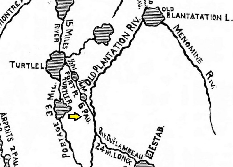
J. D. Doty 1820 map of southern shore of Lake Superior, yellow arrow marks 6 Pause Portage
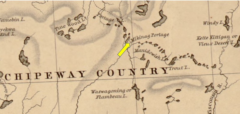
1843 J. N. Nicollet Topographical Engineer, yellow arrow marks 6 Pause Portage; Mikinag is Ojibwe for turtle
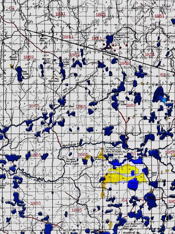
Modern Trygg maps illustrating the portage from original U.S. surveys from the 1860’s; yellow arrow marks 6 Pause Portage
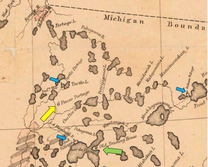
1847 map from Geologist J. G. Norwood attached to the Owen Expedition
Fur trade voyageur carrying only one pack with a tump line over his head.
.jpg)
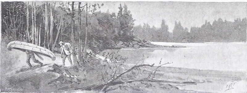
19th century portage from an 1895 article on Manitowish and Mercer Wisconsin
Backstory and Context
Text-to-speech Audio
For thousands of years, Northwoods travelers used canoes and portages to maneuver through the wilderness. Portages required travelers to carry their canoe, and trade goods and other belongings between lakes and streams. The Flambeau Trail, from the outlet of the Montreal River in Lake Superior to Long Lake, was exceptionally long, and canoes were not carried over that trail. Physically demanding portages were necessary to survive in the Northwoods before 1890. The Turtle Portage Band of the Ojibwe was located just north of 6 Pause Portage between Grand Portage and Echo Lake in Mercer, Wisconsin. Some portages like the Flambeau Trail and 6 Pause Portage were notorious, and early travelers documented the swamps and challenges.
The following 19th century journal entries by travelers illustrate 6 Pause Portage's impact:
1832 Missionary Sherman Hall wrote:
"Here we reached the portage which was to take us to the Chippewa river. As before I took the baggage while my man took the canoe, and commenced our march, hoping to reach the river, which was three of four miles distant, before we encamped. After we left the lake, we ascended on to high ground, which was covered with a heavy growth of hemlock and hard wood it was nearly sundown before we left the lake, and the darkness overtook us so soon, that we were obliged to encamp before we reached the river. We laid down our loads and kindled a fire and prepared to make ourselves as comfortable as possible. We were near a tamarack swamp, which produced a damp and unpleasant atmosphere during the night. The weather had become considerable cool during the preceeding [sic] after noon, of which I was not aware till too late to provide a sufficient quantity of wood to keep a fire during the whole night, and our encampment being in the open air and not sufficient by trees, a single blanket was not sufficient to shield me from the cold and frost, and I passed a rather uncomfortable night. This morning as soon as light, we recommenced our march through a swamp of mud and water. Everything was covered with frost, and the ground through the swamp was slightly stiffened by the cold of the night. The water which immediately pierced the deer skin shoes, which [I] wore on my feet was extremely cold and uncomfortable."
1846 Geologist A. B. Gray wrote:
"The next day we continued our course to the eastward. After a short distance by water, made another portage of 2 1/2 miles with the canoes, part of it through a deep tamarack swamp, and launched them into the main branch of the Chippewa river. This stream appeared to be about 30 feet wide where we struck it, rapid and quite deep, and, I understand, can be descended from Trout lake in canoes the whole way to the Mississippi, with but a few portages around falls or rapids."
1847 Geologist J. G. Norwood wrote:
"The outlet from Little Turtle lake is through a very narrow channel connecting it with another lake, which we crossed, and came to the beginning of what is known as "Six Pause portage." As the voyagers had to make a double portage, we took our packs and walked on to its termination, at the east branch of the Chippewa river, or as it is commonly called the Manidowish, where we arrived at noon. The trail runs over a sand barren, with the exception of the last half mile, which runs through one of the worst tamarack swamps I have ever seen. A few stunted pines, with the occasional patches of course grass, is the only vegetation supported on the high grounds.
"The Manitowish river at this point comes from the northeast, is deep and clear, about thirty feet wide, and winds through the centre of a broad wet meadow, with grass from two to five feet high."
The quotes above and maps included in this entry's images, demonstrate the importance of 6 Pause Portage as a vital link travel link.
Sources
American Board of Commissioners for Foreign Missions. Box 1, 1827-1836. St Paul: Minnesota State Historical Society.
Leffingwell, William Leffingwell Bruce . Hunting And Fishing Along The North-western Line: A Book Descriptive Of The Best Resorts In America For Deer, Bear, Goose, Duck, And Snipe Shooting. Chicago, IL. Rand, and McNally and Company Publishing , 1895.
Nicollet, Joseph . Re-imaging Joseph N. Nicollet's Mapmaking Expeditions, St. Olaf.1843. Accessed December 17th, 2022. https://www.stolaf.edu/academics/nicollet/.
Owen, David Dale. Report of a Geological Survey of Wisconsin, Iowa, and Minnesota. Philadelphia: Lippincott, Grambo, & Co., 1852.
St. Paul Minnesota. Minnesota State Historical Society. Sherman Hall. Papers 1809-1876.
Thwaites, Reuben Gold. Collections of the State Historical Society of Wisconsin. vol. XIX. Madison: Published by the Wisconsin State Historical Society, 1910.
U.S., Congress, Senate. A Report of Geologist Reconnaissance of the Chippewa Land District of Wisconsin and the Northern Part of Iowa. S. Doc. 57. 30th Congress, 1st sess., 1848.
U.S., Congress, House of Representatives, The War Department. Mineral Lands on Lake Superior. House Doc. 211. 29th Congress, 1st sess., 1846.
U.S., Congress, House of Representatives, The War Department. Schoolcraft and Allen-Expedition to Northwest Indians. House Doc. 323. 23rd Congress, 1st sess., 1832.
Trygg, J William. Composite Maps of United States Land. Surveyors' Original Plat and Field Notes. Ely MN: Trygg Land Office; 1964, 1966, 1969.
Thwaites, Reuben Gold. Collections of the State Historical Society of Wisconsin. vol. XIX. Madison: Published by the Wisconsin State Historical Society, 1910.
Nicollet, Joseph . Re-imaging Joseph N. Nicollet's Mapmaking Expeditions, St. Olaf.1843. Accessed December 17th, 2022. https://www.stolaf.edu/academics/nicollet/.
Trygg, J William. Composite Maps of United States Land. Surveyors' Original Plat and Field Notes. Ely MN: Trygg Land Office; 1964, 1966, 1969.
U.S., Congress, Senate. A Report of Geologist Reconnaissance of the Chippewa Land District of Wisconsin and the Northern Part of Iowa. S. Doc. 57. 30th Congress, 1st sess., 1848.
Unknown
Leffingwell, William Leffingwell Bruce . Hunting And Fishing Along The North-western Line: A Book Descriptive Of The Best Resorts In America For Deer, Bear, Goose, Duck, And Snipe Shooting. Chicago, IL. Rand, and McNally and Company Publishing , 1895.