Old County Highway G Bridge
Introduction
Text-to-speech Audio
While paddling down the Manitowish River, many question the concrete structure across from the Highway 51 wayside boat landing. Back in the 1920s as automobiles began to operate within the Northwoods, county and local roads were constructed to connect communities. County Highway G, was in operation by 1927 and connected the communities of Springstead and Powell to the towns of Manitowish and Mercer. Selecting the easiest route between Powell and Highway 51, road builders did not follow the more swampy railroad route. Instead, they crossed the swamp at its most narrow point and jogged the road east, crossing the Manitowish River just before old State Highway 10. The southern County G bridge concrete support wall remains at the boat landing at the wayside park and kayak landing as a reminder of the early days and automobile and truck traffic.
The old Highway G ridbge is located on public land and has excellent parking near the river. The site is easy to locate...just follow the Department of Transportation wayside signs. Whether traveling by car, bicycling on the trail, or paddling down the river, travelers will discover a scenic site with a great story.
Images
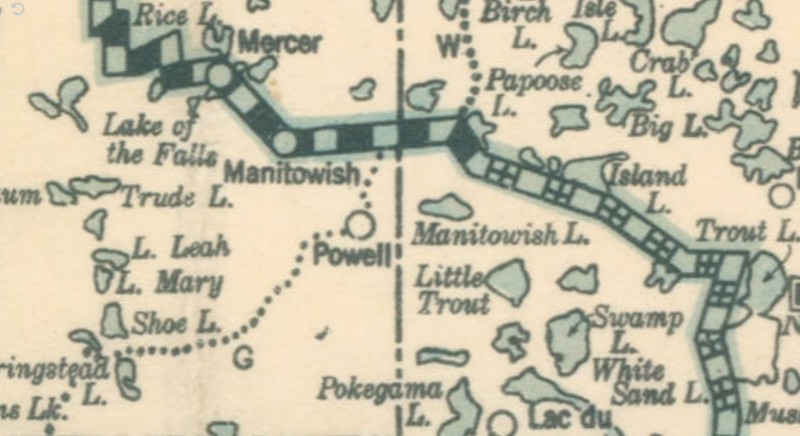
1927 map illustrating County Highway G
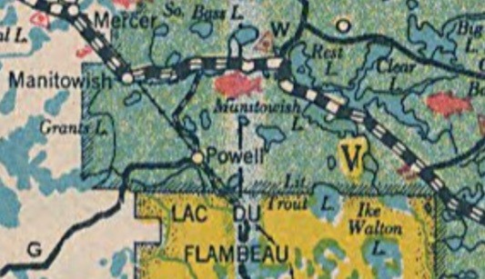
1939 map illustrating County Highway G
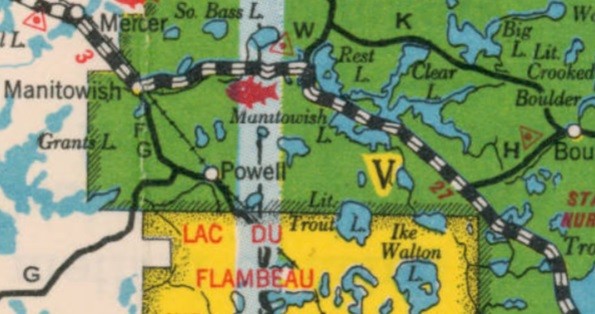
1940 map illustrating County Highway G shifting to a new route as part of County Highway F
Moonshine moving from Lac du Flambeau to Manitowish WI
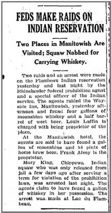
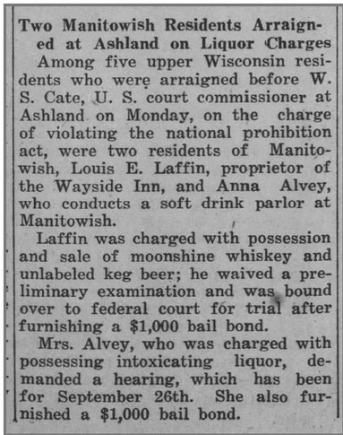
Arrests at Manitowish soda parlor and Wayside Inn
1927 Manitowish bootleggers selling moonshine to Lac du Flambeau
1937 image of County G Bridge over the Manitowish River and the intersection of Highways 51 and County G.

Backstory and Context
Text-to-speech Audio
County Highway G was an important route for travel and represents one of the earliest automobile routes linking several Northwoods communities. From 1889 to roughly 1915, railroads provided the bulk of the transportation to the Northwoods, and local livery services using horses or mules would move visitors and supplies from railroad stations to their destinations. Stagecoach routes were cited on early maps linking the Manitowish Station to destinations like the Divide Resort in Winchester. With the introduction of numerous automobiles to the Northwoods by the early 1920s, road building began in earnest. Early Northwoods roads were made of mostly sand, pit-run fill and gravel.
County Highway G operated from 1927-1939, before being rerouted from Powell to the town of Manitowish on county trunks F and G. Ultimately, this route became Highway 182 around 1948. Interestingly, 1927 marks both the year County Highway G became operational, and State Highway 10 became Highway 51. During County G's existence, Northwoods commerce and transportation was shifting to accommodate new demand. Tourists and travelers were less dependent on railroads and began to travel by automobile to the Northwoods. New roads and business began to line these routes to facilitate car travel. Tourists were no longer tethered to resorts on the American Plan, which included both accommodations and dining. Roadside diners, gas stations, motels, auto repair shops, and other businesses began to appear in greater frequency in the Northwoods. With a better route established to the town of Manitowish around 1940, the bridge was taken out for scrap to support industry during World War II.
Camp Mercer CCC enrollees would have used County Highway G often for work details and traveling to Lac du Flambeau for athletic competitions. Resorts, camps and new roadside businesses all benefited from this new route. Logging was transitioning from railroad logging to truck and tractor logging, and County G would have helped local loggers transport timber to area mills and railroads.
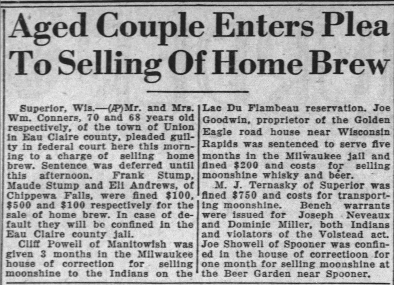
County G would have also linked moonshiners from Lac du Flambeau and Springstead with operations along Highway 51. Prohibition arrests in 1932 at a Manitowish "soda parlor" and the Wayside Inn (River's Edge Lodge and Outfitters today) were linked to a Lac du Flambeau bootlegger named Mary King. Cliff Powell of Manitowish was sentenced for selling moonshine in Lac du Flambeau in 1927. Powell would have most certainly used newly constructed Highway G to bootleg his goods. Clearly, moonshine was moving along Northwoods roads on a regular basis.
Sources
Wisconsin Highway Commission. 1927 Wisconsin Official State Highway Map, State of Wisconsin Department of Transportation. January 1st, 1927. Accessed December 11th, 2022. https://wisconsindot.gov/Documents/travel/road/hwy-maps/state-maps/hwy_map_archive/1927StateHighwayMapWI.pdf.
Wisconsin Highway Commission. 1939 Wisconsin Official State Highway Map, State of Wisconsin Department of Transportation. January 1st, 1939. Accessed December 11th, 2022. https://wisconsindot.gov/Documents/travel/road/hwy-maps/state-maps/hwy_map_archive/1939StateHighwayMapWI.pdf.
Wisconsin Highway Commission. 1940 Wisconsin Official State Highway Map, State of Wisconsin Department of Transportation. January 1st, 1940. Accessed December 11th, 2022.
https://wisconsindot.gov/Documents/travel/road/hwy-maps/state-maps/hwy_map_archive/1940StateHighwayMapWI.pdf.
Rhinelander Daily News. Feds Make Raids on Indian Reservation , Manitowish Waters Historical Society . September 10th, 1932. Accessed December 11th, 2022. https://mwhistory.pastperfectonline.com/Archive/011DA957-192C-42B5-AA7C-811394342532#gallery-1.
Iron County Miner . Two Manitowish Residents Arraigned as Ashland on Charges, Manitowish Waters Historical Society. September 16,1937. Accessed December 11th, 2022. https://mwhistory.pastperfectonline.com/Archive/011DA957-192C-42B5-AA7C-811394342532#gallery-2.
"Aged Coupled Enters Plea To Selling Home Brew." The Sheboygan Press (Sheboygan) September 14th, 1927.
STATE CARTOGRAPHER'S OFFICE. Mercer County, WISCONSIN HISTORIC AERIAL IMAGERY FINDER. November 3rd, 1932. Accessed December 19th, 2022. https://maps.sco.wisc.edu/WHAIFinder/#13/46.1313/-89.9585.
Wisconsin Highway Commission. 1927 Wisconsin Official State Highway Map, State of Wisconsin Department of Transportation. January 1st, 1927. Accessed December 11th, 2022. https://wisconsindot.gov/Documents/travel/road/hwy-maps/state-maps/hwy_map_archive/1927StateHighwayMapWI.pdf.
Wisconsin Highway Commission. 1939 Wisconsin Official State Highway Map, State of Wisconsin Department of Transportation. January 1st, 1927. Accessed December 11th, 2022. https://wisconsindot.gov/Documents/travel/road/hwy-maps/state-maps/hwy_map_archive/1939StateHighwayMapWI.pdf.
Wisconsin Highway Commission. 1940 Wisconsin Official State Highway Map, State of Wisconsin Department of Transportation. January 1st, 1940. Accessed December 11th, 2022. https://wisconsindot.gov/Documents/travel/road/hwy-maps/state-maps/hwy_map_archive/1940StateHighwayMapWI.pdf.
Rhinelander Daily News. Feds Make Raids on Indian Reservation , Manitowish Waters Historical Society . September 10th, 1932. Accessed December 11th, 2022. https://mwhistory.pastperfectonline.com/Archive/011DA957-192C-42B5-AA7C-811394342532#gallery-1.
Iron County Miner . Two Manitowish Residents Arraigned as Ashland on Charges, Manitowish Waters Historical Society . Invalid date. Accessed December 11th, 2022. https://mwhistory.pastperfectonline.com/Archive/011DA957-192C-42B5-AA7C-811394342532#gallery-2.
"Aged Coupled Enters Plea To Selling Home Brew." The Sheboygan Press (Sheboygan) September 14th, 1927.