Benson Lake's Logging Traditions
Introduction
Text-to-speech Audio
Benson Lake is located on the western most part of the Manitowish chain and flows into the Flambeau and Chippewa rivers. A mix of public and private land surrounds the 28-acre lake. The inlet of Manitowish River is wide, shallow and sandy due to repeated logging drives from over 100 years ago. Original survey notes from 1862 suggest that Benson and Rest lakes were logged during the Civil War. River drive logging remnants rise out of the 15-foot-deep lakebed and are still visible as deadheads. Just up the hill of Benson Lake's southern shore marks the termination of a railroad logging spur operated by the Lac du Flambeau Lumber Co. Red pines and hardwoods were moved to mills by numerous logging companies using that railroad spur.
Images
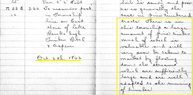
1862 Surveyor's notes documenting "...that a large amount of pine...will soon be taken to market".
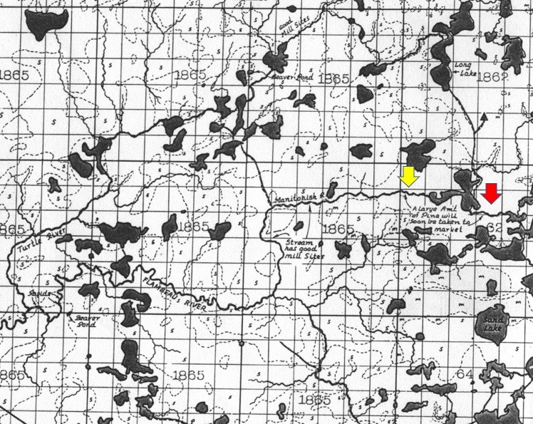
Map from William Trygg illustrating the original survey field notes. Yellow arrow marks Benson Lake and the red arrow marks Rest Lake.
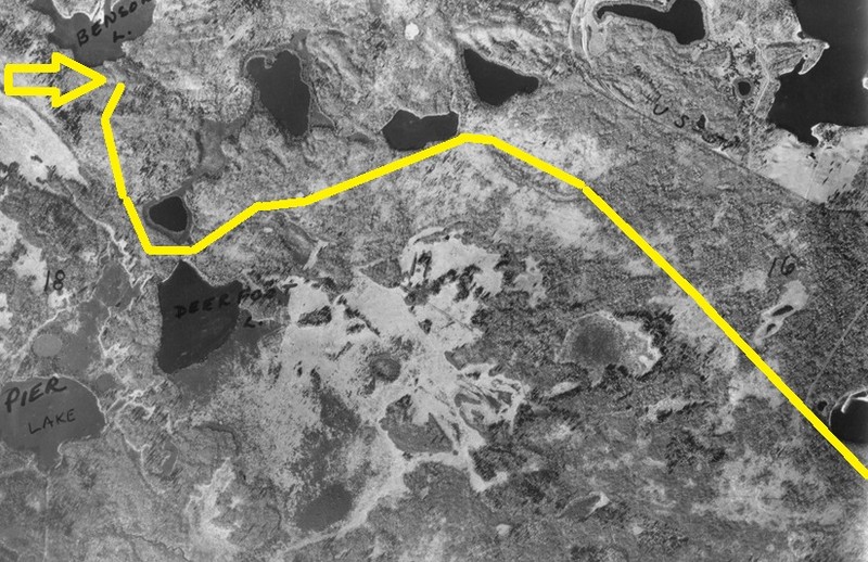
1937 Image of Benson Lake with railroad spur marked in yellow
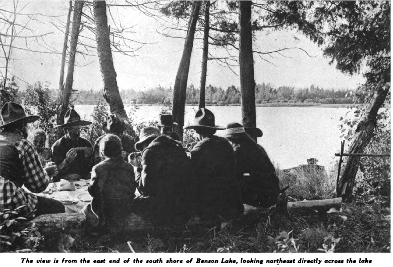
1918 Outer's Magazine image of Benson Lake camp on the southern shoreline.
Backstory and Context
Text-to-speech Audio
Benson Lake has a unique geomorphology, marking the transition of the Manitowish River as a stream running through a highlands with many lakes to a meandering stream with more lowlands and sedges. The inlets of the Manitowish River into Vance, Sturgeon and Benson lakes all show the impacts of rushing water and erosion from river drive logging. In Benson Lake's inlet, a large sandbar was pushed into the lake. For context, well before the Rest Lake Dam, A. B. Gray in 1846 described the lakes and Manitowish River, "although the stream curved around in every direction, occasionally opening into small and picturesque lakes, surrounded by high land, with excellent pineries, and narrowing again to a width barely sufficient for the passage of a canoe." Today, the river channels are much larger on Benson Lake due to logging practices.
Early historians suggested river drive logging around the Manitowish chain began in the late 1870s or early 1880s. But, the 1862 land surveys documented white pine ready for market at the inlet of Rest Lake and the north shore of Benson Lake near the outlet: “There is in this township a large amount of pine timber much of which is valuable and will very soon be taken to market by floating down the streams which are sufficiently large and are well adapted to the running of lumber.” Since this land survey was ongoing, the timber cited by the surveyors was most certainly plundered. Before surveyor documents could be recorded with the government, private timber cruisers had previously conveyed to clandestine loggers the rich timber resources of our community. Importantly, Manitowish Waters’ excellent river driving conditions for Phase 1 logging were obvious to early explorers. Even more notable, the alleged trespassing and timber stealing occurred while the United States was shifting human resources to fight the Civil War, limiting enforcement of timber trespass laws. These timber abuses did not go unnoticed by anxious land agents, speculators, logging interests, universities and out-of-state (absentee) capitalists. In 1865, a land office agent cited, “One third to one half of the best pine lumber on the Chippewa had been cut off by trespassers wherever it was most accessible.” The timber along the Manitowish and Benson Lake was very accessible.
During Phase 2 railroad logging, Manitowish Waters transitions to a secondary logging area that was only accessed by tertiary rail routes and logging spurs. Access rail lines to Manitowish Waters were near or at the very end of distant railroad lines. 20th century logging first depended on the Chicago Northwestern Railroad (C&NW) to reach the spur to Benson Lake. The rail line through the Powell Marsh area to Little Star Lake was owned by Flambeau Lumber Company, which owned several spurs off of the C&NW Ashland Division main line. It was contracted by the federal government to the Lac du Flambeau Indian Reservation, although the company had timber located off of the reservation as well. This rail spur would ultimately connect to Benson Lake. Numerous other logging companies like Brooks and Ross paid to use the rail spur to remove timber.
Sources
Potter, E C. In Dam, Sturgeon and Benson Lakes, Manitowish Waters Historical Society. May, 1918. Accessed December 5th, 2022. http://ppolinks.com/mwhistory/2018_8_3.pdf.
U.S., Congress, House of Representatives, The War Department. Mineral Lands on Lake Superior. House Doc. 211. 29th Congress, 1st sess., 1846.
Sasse, Timothy. Vilas County, Wisconsin Logging Railroads. January 5th, 2000. Accessed December 6th, 2022. https://sassmaster.tripod.com/vilas.html.
Trygg, William. MI 16 WI 16, Trygg Historical Maps .1964. Accessed December 6th, 2022. https://trygghistoricalmaps.com/products/mn-16-wi-16/.
Wisconsin Board of Commissioners of Public Lands. Affidavit Township 42 North, Range 5 East, Wisconsin Public Land Survey Records: Original Field Notes and Plat Maps. October 6th, 1862. Accessed December 6th, 2022. https://digicoll.library.wisc.edu/cgi-bin/SurveyNotes/SurveyNotes-idx?type=turn&issueid=Sur
veyNotes.INT050E02&entity=SurveyNotesINT050E000114&isize=L&twp=T042NR005E.
Wisconsin Board of Commissioners of Public Lands. Affidavit Township 42 North, Range 5 East, Wisconsin Public Land Survey Records: Original Field Notes and Plat Maps. October 6th, 1862. Accessed December 6th, 2022. https://digicoll.library.wisc.edu/cgi-bin/SurveyNotes/SurveyNotes-idx?type=turn&issueid=SurveyNotes.INT050E02&entity=SurveyNotesINT050E000114&isize=L&twp=T042NR005E.
Trygg, William. MI 16 WI 16, Trygg Historical Maps .1964. Accessed December 6th, 2022. https://trygghistoricalmaps.com/products/mn-16-wi-16/.
Manitowish Waters Historical Society
Potter, E C. In Dam, Sturgeon and Benson Lakes, Manitowish Waters Historical Society. May, 1918. Accessed December 5th, 2022. http://ppolinks.com/mwhistory/2018_8_3.pdf.