The French and the Lewis & Clark Expedition Historical Marker
Introduction
Text-to-speech Audio
With the Louisiana Purchase in 1803, the fledgling United States was expanding into former French territory. After being sent to explore the newly American territory, Lewis and Clark employed several Frenchmen native to the territory as guides, trappers, boatmen, and translators. Most of the Frenchmen along for the journey were recruited around St. Louis, and turned back after the group wintered in Mandan land in the Dakota territories. Other French trappers and frontiersmen joined up with the expedition along the way. The marker is placed right next to the Lewis and Clark : Corps of Discovery Statue in downtown Kansas City.
Images
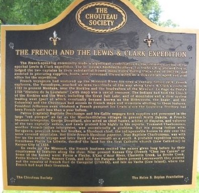
English side of the marker, courtesy of Thomas Onions
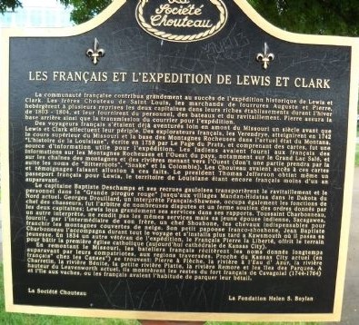
French side of the marker, courtesy of Thomas Onions
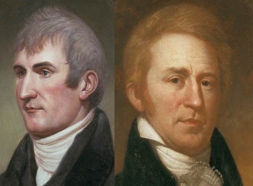
Meriwether Lewis (left) and William Clark (right)
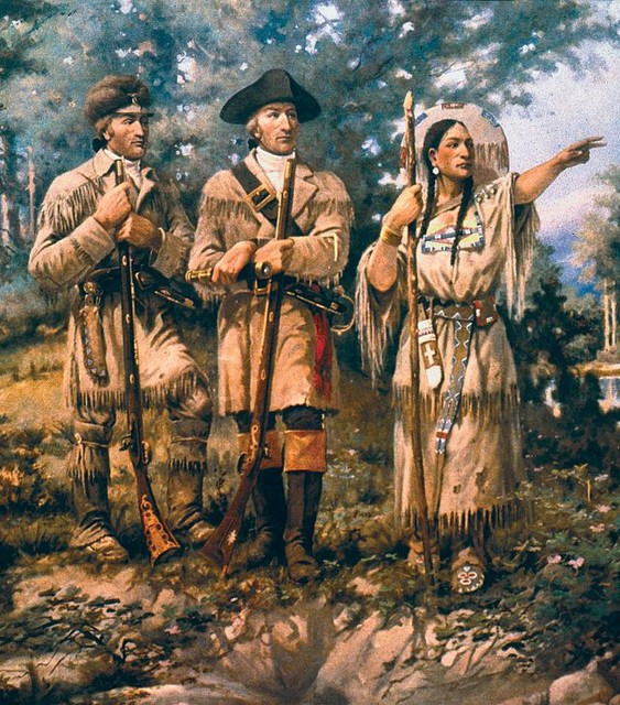
A mural depicting Lewis and Clark with Sacagawea
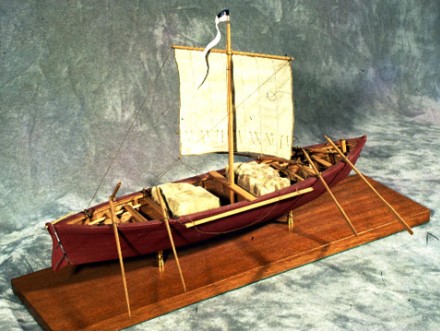
Scale model of the Red Pirogue, courtesy of Richard Boss
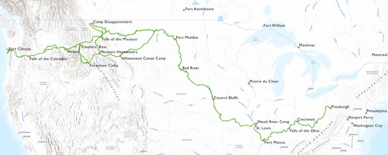
The route of the Corps of Discovery
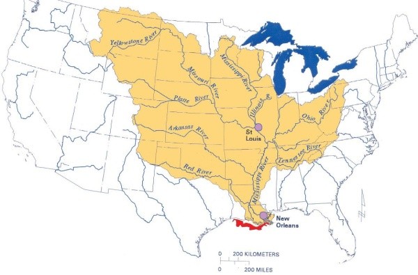
The territory of the Mississippi River Drainage Basin, courtesy of the EPA
Backstory and Context
Text-to-speech Audio
In 1803, American delegates in Paris negotiated the purchase of the entire Mississippi River Drainage Basin from Napoleon’s French First Republic. The French had sold this territory to the Spanish in the wake of the Seven Years War in 1762, only to gain it back in 1800 after defeating Spain in one of the early wars of the French Revolution. Very little Spanish presence had been maintained in the territory and much of the land was remote and ungoverned.
This land had not been fully mapped and explored at the time of the sale, so it was not known to what extent the Mississippi’s tributaries reached. The hope was that it extended to the Pacific Ocean and a water route through North America could be established. Set out by President Thomas Jefferson, Army Captain Meriwether Lewis and Second Lieutenant William Clark led an expedition known as the Corps of Discovery, to explore and document these newly American lands a year after their purchase. What maps did exist of the territory were made and possessed by the French that lived out in the west, and these maps were heavily relied upon for portions of the Corps’ journey. The Louisiana Territory, which includes modern day Missouri, was largely populated by Native Americans and despite spending decades under Spanish rule, most of the European presence in the territory was still French. Many of the fur traders and settlers from the days of French rule remained prominent in the Missouri area and beyond for many years after the end of France’s official presence on mainland North America.
By the time the Corps arrived at St. Louis in December of 1803, it was still a largely French speaking city with the wealthy Chouteau family still pulling influence in the area. While they were in the area, the Corps recruited several Frenchmen living around the St. Louis area to accompany them on their journey. These French hired hands were referred to by the generic term engagés. When spring came, the Corps departed down the Missouri River in small river boats known as pirogues. One of these boats was painted red and known as the “French Pirogue” as it was crewed by nine French-Canadian engagés who were led by Jean Baptiste Deschamps. The Frenchmen hired around St. Louis agreed to only go as far as Mandan land in the Dakota territories. The Corps of Discovery was a military expedition, and as such most of its men were American soldiers. The engagés were civilians by comparison and had different responsibilities and expectations accordingly. A few days after leaving St. Louis, about 60 miles up river the Corps encountered the small French speaking village of La Charrette. The Corps spent a night with the villagers who shared what little food they had. This village proved to be the final permanent settlement inhabited by White people the expedition encountered. Later in the journey, the Corps recruited some experienced French frontiersmen to accompany them on their route. The Frenchmen that had been living among Native Americans in the frontier often spoke multiple native languages, making them indispensable as translators for large stretches of the journey.
While the party was wintering with the Mandan Indians in what is modern day North Dakota, they recruited a French frontiersmen named Toussaint Charbonneau who brought along his young Native American wife Sacagawea. Both served the Corps well as guides and translators during the final portions of the journey towards the Pacific Ocean. During this leg of the expedition, the Corps was also accompanied for a time by prominent North West Company fur trader François-Antoine Larocque.
The text of this historical marker reads as follows:
The French-speaking community made a significant contribution to the ultimate success of the epochal Lewis & Clark expedition. The St. Louis Chouteau brothers, fur traders Auguste and Pierre, lodged the two captains in their substantial homes many times during the winter of 1803-04, and assisted in procuring supplies, boats, and personnel. Pierre acted as a downstream agent and post office for the expedition.
French voyaguers had ventured up the Missouri for over a century before 1804. French explorers, the Verendryes, reached an area two-thirds of the way along Lewis & Clark’s route in 1742 in present Montana, near the Rockies and the headwaters of the Missouri. Le Page du Pratz’s 1758 “Histoire de la Louisiane” (with map) was a useful resource. The Indians had told the French of the Rockies and the West, including the Great Salt lake, and of mountains and a river system leading west (part of which eventually became known as the Bitterroots, the Snake, and the Columbia) and the Chouteaus had access to French maps and memoires alluding to these features. President Jefferson even obtained a French passport for Lewis since the Louisiana Territory had been French until less than a year before.
Patron (captain) Baptiste Deschamps and his Gaulle engages took supplies and personnel in the large “red pirogue” as far as the Mandan-Hidatsa villages in present North Dakota. A French-Shawnee interpreter, George Drouillard, also acted as chief hunter, arbiter of disputes, and enforcer of the two captains’ orders, and Lewis praised him highly in his reports. Toussaint Charbonneau, another French-Indian interpreter, was occasionally a problem. But his young Indian wife, Sacagawea, procured from her brother, a Shoshoni chief, the indispensable horses to ride over the snow covered mountains. Her little French-Shoshoni papoose, Jean Baptiste Charbonneau, was with her on the entire voyage and later lived at kawsmouth as a youth. A probable expedition veteran, Frenchman Pierre La Liberte, deeded the land for the first Catholic church (now Cathedral) in Kansas City in 1834.
En route up the Missouri, the French boatmen recited the names given long before by their countrymen to features along the river. Near present Kansas City (French “Chez les Canses” or home of the Kansa) were: Pierre a Fleche, L’Eau d’Azur River, Charretin Creek, La Benite Creek, Petite Riviere Platte, Remore Creek, and Isles des Parques. Above present Leavenworth they pointed out the remains of French Fort de Cavagnial (1744-64) and Isle au Vache (Cow Island), where the French had kept their livestock.
Sources
The French and the Lewis & Clark Expedition, The Historical Markers Database. Accessed July 28th, 2022. https://www.hmdb.org/m.asp?m=86207.
Mussulman, Joseph . The Pirogues, Discover Lewis & Clark. Accessed August 2nd, 2022. https://lewis-clark.org/boats/pirogues/.
Townsend, Kristopher . The Engagés, Discover Lewis & Clark. Accessed August 2nd, 2022. https://lewis-clark.org/members/the-engages/.
Brown-Trogdon, Jo Ann . The St. Charles Boatmen, Discover Lewis & Clark. Accessed August 2nd, 2022. https://lewis-clark.org/members/st-charles-boatmen/.
Adams, Mary P. “Jefferson’s Reaction to the Treaty of San Ildefonso.” The Journal of Southern History 21, no. 2 (1955): 173–88. https://doi.org/10.2307/2955116.
Hastings, Donald L. “La Charrette: Was It a Winter Encampment Objective of the Lewis and Clark Expedition?” Journal of the Illinois State Historical Society (1998-) 97, no. 1 (2004): 6–26. http://www.jstor.org/stable/40193891.
Engagés on the Lewis and Clark Expedition, National Park Service. Accessed August 2nd, 2022. https://www.nps.gov/articles/engag%C3%A9s-on-the-lewis-and-clark-expedition.htm.
https://www.hmdb.org/m.asp?m=86207
https://www.hmdb.org/m.asp?m=86207
https://www.nps.gov/knri/learn/historyculture/lewis-and-clark.htm
https://en.wikipedia.org/wiki/Sacagawea
https://lewis-clark.org/boats/pirogues/
https://lewis-clark.org/primary/the-trail/
https://www.epa.gov/ms-htf/mississippiatchafalaya-river-basin-marb