Brush Creek Fountains
Introduction
Author-Uploaded Audio
Local historian and author Bill Worley tells a brief history of Brush Creek and the shaping of the Country Club Plaza
Text-to-speech Audio
Designed by International Architects Atelier, the three geysers that create the Brush Creek Fountains were installed just south of the Country Club Plaza as part of ongoing improvements to Brush Creek and a beautification project completed in 1996. Brush Creek is a 10-mile tributary to the Blue River which has served as a natural watershed for centuries. Originally a swamp and location of unsightly industry, this area of land in the Brush Creek Basin was purchased in the early 1900s and transformed into beautiful residential and commercial developments. The waterway was paved in 1935 by Tom Pendergast as part of a plan to make Kansas City “the greatest inland city in America,” not realizing the improvement created favorable conditions for flooding. Many floods occurred over the years, with the most devastating taking place in September 1977, resulting in 25 deaths and one hundred million dollars in damages. This urged Councilmen Cleaver and Watkins to take action, first introducing the “Cleaver Plan” in the early 80s. The plan initiated a flood emergency team, replaced bridges, and improved the water quality with the addition of pumps for circulation and the Brush Creek Fountains.
Images
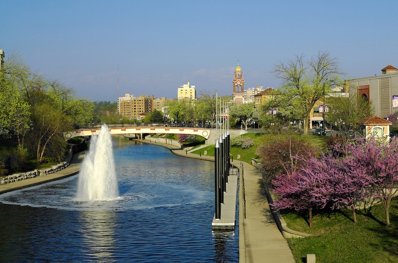
The Brush Creek Fountain geyser at Wyandotte Street, near the gondola dock.
A recent photo of Brush Creek near the Country Club Plaza.
.jpg)
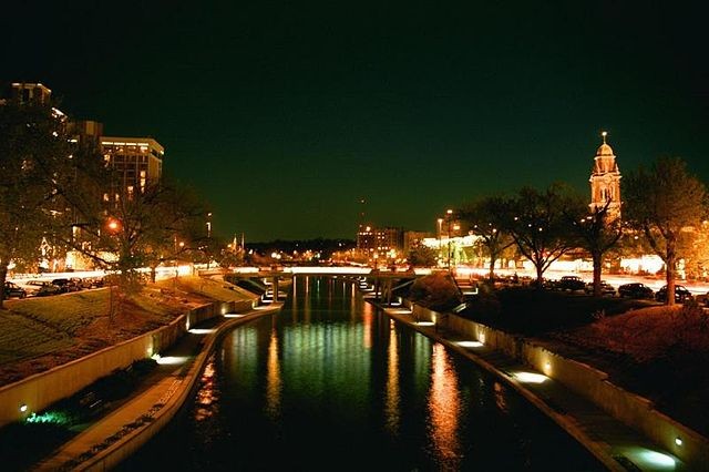
The Plaza Riverwalk along Brush Creek lit up at night.
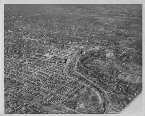
An aerial view of Brush Creek looking northeast toward the Country Club Plaza c.1930~. Courtesy of Missouri Valley Special Collections, Kansas City Public Library.
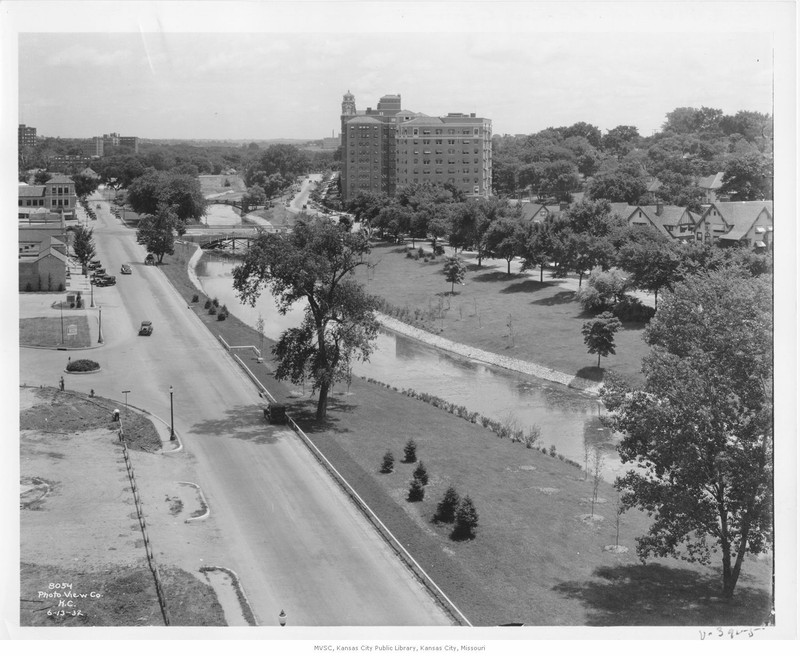
A view looking east from Jefferson Street c.1932. Courtesy of Missouri Valley Special Collections, Kansas City Public Library.
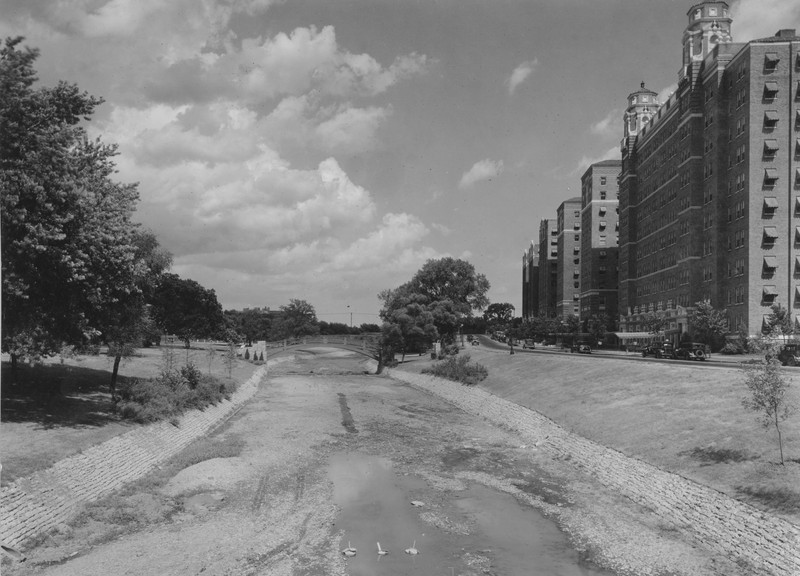
A view of Brush Creek unpaved, looking east-northeast from the Wornall bridge c. 1933. Courtesy of State Historical Society of Missouri via Pendergast KC.
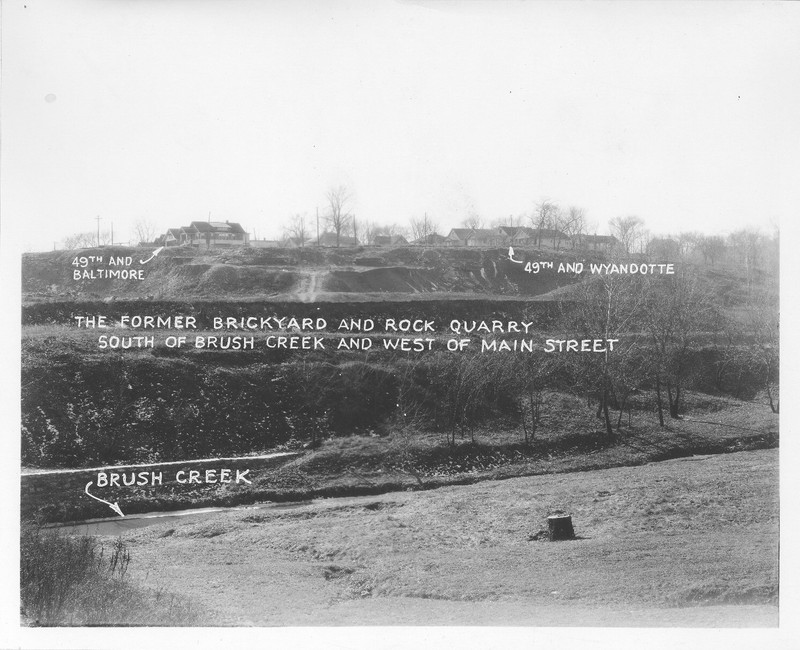
A view near Brush Creek looking south at the brickyard and rock quarry that once operated here c.1926. Courtesy of Missouri Valley Special Collections, Kansas City Public Library.
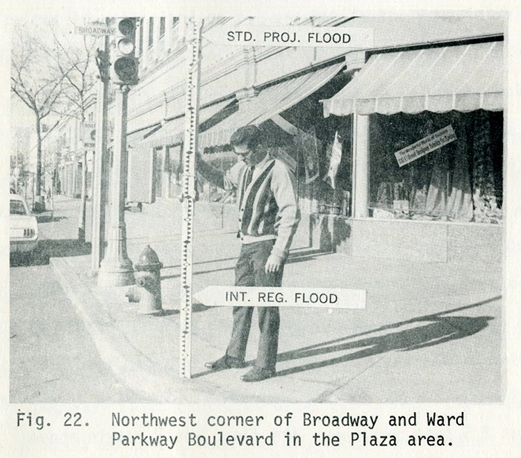
As part of a 1970 report, the Corps of Engineers projected possible flood levels for the Plaza. Courtesy of Missouri Valley Special Collections, Kansas City Public Library.
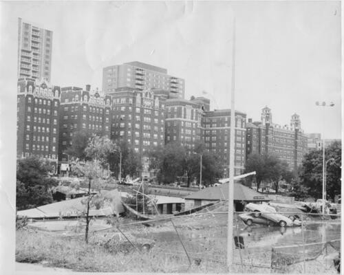
Damage from the 1977 Brush Creek flood looking southwest from Main Street. Courtesy of Missouri Valley Special Collections, Kansas City Public Library.
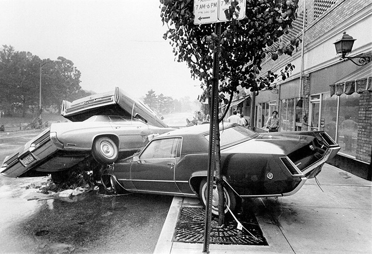
The 1977 Brush Creek flood was so strong it moved cars on top of one another, as seen here on Ward Parkway. Courtesy of Missouri Valley Special Collections, Kansas City Public Library.
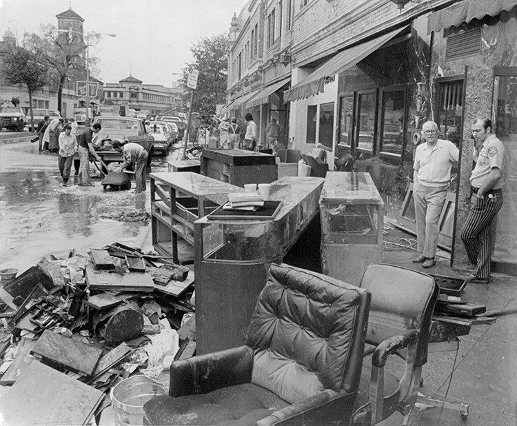
Debris accumulated along Nichols Road from the 1977 Brush Creek flood, which inundated many businesses on the Country Club Plaza. Courtesy of Missouri Valley Special Collections, Kansas City Public Library.
Low bridges created choke points for debris during floods, as seen here in September 1977. Courtesy of Missouri Valley Special Collections, Kansas City Public Library.
.jpg)
Backstory and Context
Text-to-speech Audio
Brush Creek is a tributary of the Blue River and serves as a watershed for the Blue River Basin. The 10.5 mile creek begins in Johnson County, Kansas flowing north-northeast into Jackson County, Missouri and continues east before reaching the Blue River. Ironically, it was named for the foliage that once grew along its banks. The most prominent and well-known area of development around Brush Creek is at the site of the Country Club Plaza, developed by J.C. Nichols in the early 1920s.
The history of the Brush Creek Basin dates back to 1864 during the Civil War, where the two-day Battle of Westport took place. At the time European settlers moved to the area in the late 1880s, it became the site of many industrial trades and farms as it was situated south of city limits. This area included a brickyard, a 20 foot deep swamp, a dump site, a stone quarry, a lumberyard, and a coal mine located to the east near the Blue River. By 1893, landscape architect and engineer George Kessler was hired to develop the Kansas City’s Parks and Boulevards System and was completed in 1915. The plan was designed with city development and expansion in mind, including the construction and paving of thoroughfares, integrated landscaping, and incentives for residential development.
The land in the Brush Creek Basin was first acquired in the early 1900s for residential use by William Rockhill Nelson and J.C. Nichols. After developing several surrounding neighborhoods, Nichols acquired the plat of land where he would build the Country Club District. Apart from residential homes, the plan for the district included a shopping center which became the Country Club Plaza and opened in 1923. By 1931, political boss Tom Pendergast put forward a ten-year plan intending to make Kansas City “the greatest inland city in America” by improving hospitals, roads and sewers, increasing job opportunities, and ensuring the development of buildings. Part of the ten-year plan included the widening and paving of Brush Creek to control flooding and in 1935, Pendergast’s owned Ready-Mixed Concrete Company was hired. Some backlash followed politically and environmentally, as the work done actually created a more conducive environment for flooding with decreased foliage and increased water speeds. A 1970 report from the U.S. Corps of Engineers cautioned that Brush Creek could reach flood levels within an hour of a heavy runoff event.
The most devastating flood occurred in 1977 when 16 inches of rain fell on September 12 and into the night, cresting up to 6 feet high in some areas. The rushing water moved massive amounts of debris, swept cars away, and caused damage to streets, bridges, and structures; a broken gas main ignited, causing an explosion which started fires in buildings along 48th Street; and half of the businesses on the Country Club Plaza (77 of 155) were inundated. The flood resulted in over one million dollars worth of damage and tragically the deaths of 25 Kansas Citians. A state of emergency was declared and the city implemented an “80-day clean-up” effort. Plaza businesses began repairs and reopened in this time, however, hundreds of families to the east (downstream) remained in temporary housing for months following. Councilman Bruce R. Watkins led an effort for property owners to call out the “unevenness” of City Hall’s disaster response and [then] Councilman Emmanuel Cleaver II testified to Congress, which resulted in a proposal for flood control measures and a beautification plan.
The “Cleaver Plan'' was introduced in the early 1980s which called to widen and deepen Brush Creek and to replace the low bridges which eliminated choke points of debris, finally passing in 1987. During the rebuilding phase, Plaza businesses transitioned from neighborhood shops to higher-end retailers and in 1991, the city partnered with the Corps of Engineers for the beautification project. Over the next several years, water pumps and three geyser-like fountains were installed to increase water circulation which helped to improve the water quality by reducing fecal coliform bacteria. At one time, the bacteria was 10-15 times higher than the maximum recommended levels, giving the waterway the nickname “Flush Creek.” After a 1998 flash flood that took the lives of 12 residents, a flood emergency management plan and team was created. In addition, the Plaza Riverwalk and a gondola were established, and the Sister Cities International Bridge replaced a smaller footbridge damaged by the flood. Most recently, a 25-year plan to improve sewage runoff and sanitation was introduced in a 2010 deal with the Environmental Protection Agency.
Features along Brush Creek
- Brush Creek Fountains (times of operation vary) - (1) near gondola dock at Wyandotte St; (2) at Baltimore Ave; (3) between Brookside Blvd and Oak St
- Sister Cities International Bridge - Pedestrian bridge honoring the relationships between Kansas Cities twelve Sister Cities
- Ambiance On the Water - Gondola rides - Generally runs from April to October by appointment
- Plaza Riverwalk - 1 mile paved path from Roanoke to Rockhill (paved on both sides) - Trail extends further east to Blue Banks Park at the mouth of the Blue River
- Greenway Park - From Brookside Blvd east to the Blue River
Sources
Worley, William S.. J. C. Nichols and the Shaping of Kansas City: Innovation in Planned Residential Communities. University of Missouri Press, 1993.
Kansas City Park and Boulevard System, American Society of Civil Engineers. Accessed April 25th 2022. https://www.asce.org/about-civil-engineering/history-and-heritage/historic-landmarks/kansas-city-park-and-boulevard-system.
Nichols, Jesse Clyde. Planning for Permanence: the Speeches of J.C. Nichols. Western Historical Manuscript: Country Club Plaza, State Historical Society of Missouri. Accessed April 25th 2022. https://files.shsmo.org/manuscripts/kansas-city/nichols/JCN081.pdf.
McCourt, Walter Edward. The Geology of Jackson County . Missouri Bureau of Geology and Mines, ser. second, vol. XIV. Published 1917.
Our Watershed, A History of Brush Creek, Flatland KC. February 8th 2017. Accessed April 25th 2022. https://www.flatlandkc.org/public-works/overviews-introductions-public-works/watershed-history-brush-creek/?gclid=Cj0KCQjw3v6SBhCsARIsACyrRAm3yFT-LSOYWxYSSZxMEVaAmvUSelYarm7l6IonrZR3B-oLnmGrnBgaAu84EALw_wcB.
Brush Creek/Plaza Walking Trail, KC Hiker. Accessed April 25th 2022. https://www.kansascityhiker.com/jackson-county-trails/brush-creek-trail-plaza-kc.
Report "Flood Control Project Revamps Communities." FEMA December 9th 2010.
Coveny, Raymond M.. The 1977 and 1998 Brush Creek Flash Floods, Kansas City, Accessed April 25th 2022. https://share.mo.gov/nr/mgs/MGSData/Books/Special%20Publications/Geologic%20Field%20Trips%20in%20the%20Greater%20Kansas%20City%20Area%20(Western%20Missouri,%20Northeastern%20Kansas,%20and%20Southeastern%20Nebraska)/SP-011_Original%20Digital%20Documents/09Coven3y2.pdf.
Brush Creek Fountains, City of Fountains. Accessed August 1st, 2022. https://cityoffountains.org/brush-creek-fountains/.
https://kcparks.org/places/brush-creek-greenway/
https://kcmogo.com/kc-tourism-brush-creek.php
https://commons.wikimedia.org/wiki/File:Brush_creek.jpg
https://kchistory.org/image/country-club-plaza
https://kchistory.org/image/country-club-plaza-12
https://pendergastkc.org/collection/10554/k0054-v11p277-01/brush-creek-paving
https://kchistory.org/islandora/object/kchistory%3A112775/datastream/OBJ/view
https://kchistory.org/blog/plaza-flood-%E2%80%94-kcq-investigates-1977-disaster
https://kchistory.org/image/1977-flood-country-club-plaza
https://kchistory.org/blog/plaza-flood-%E2%80%94-kcq-investigates-1977-disaster
https://kchistory.org/blog/plaza-flood-%E2%80%94-kcq-investigates-1977-disaster
https://kchistory.org/blog/plaza-flood-%E2%80%94-kcq-investigates-1977-disaster