Thayer, WV
Introduction
Text-to-speech Audio
Images
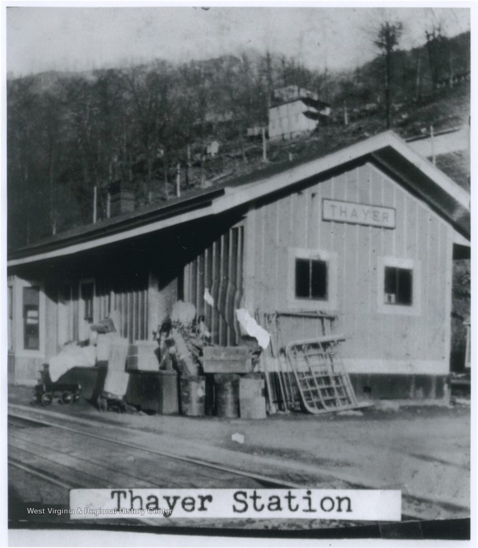
The rail station on the main line of the Chesapeake & Ohio railroad.
Thayer residents gathered for a baptism ca. 1920.

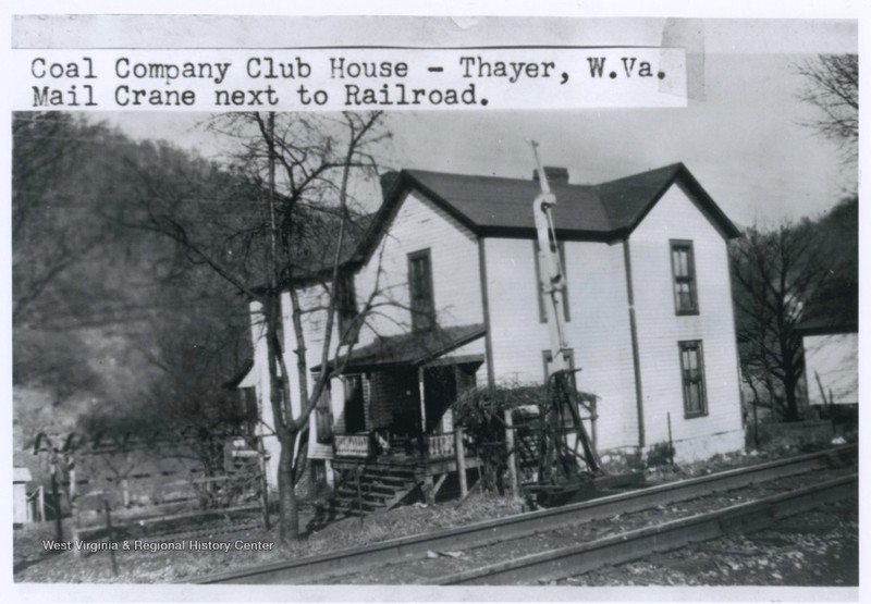
The Coal Company Club House at Thayer.
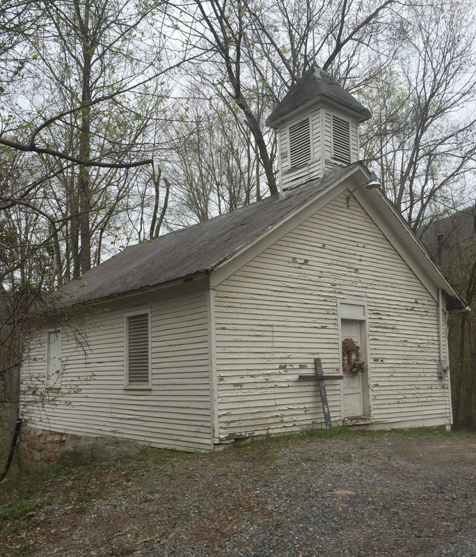
Little Rock Assembly Church.
Eastern side of boarding house.
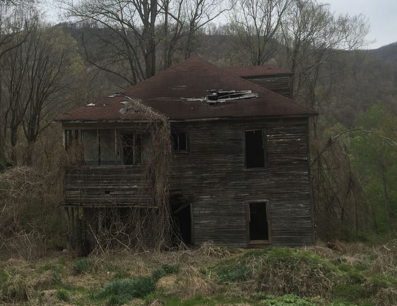
Northern side of boarding house.
Backstory and Context
Text-to-speech Audio
Of the many coal mining towns that came and went along the New River Gorge, Thayer offers one of the most interesting and compelling histories. The community has the distinction of being one of the few towns that survived the end of the mining operations that gave rise to its creation. Thayer was the company town for the Ephraim Creek Coal and Coke Company that operated the Buffalo and Slater mines. The first to open was the Slater mine, upstream of the community. It was a drift mine working the Fire Creek seam, a three-foot high seam of coal. The Buffalo mine was located at Ephraim, downriver of the town. It was also a drift mine working the same coal seam. When the Ephraim Coal and Coke Company combined operation of the two mines, it was anticipated they would combine to produce an astounding 1,000 tons of coal daily.
The valuable flatland along the New River was a prime location for a town. The town was built on both sides of the main line of the Chesapeake and Ohio railroad. As the population grew, the town expanded to the mountainside above the town. At its peak, the town contained a train depot, theater, company store, company offices, and company housing. With the exception of a few houses, all of these buildings have been lost to time. The theater had the capacity to seat one thousand people. When the stage was not being utilized, the seats could be removed so the area could be used as a dance hall. The theater must have been an impressive building as it also boasted a billiards area and a bowling alley. Surely, these entertainment opportunities attracted miners and their families from other communities throughout the gorge and surrounding areas.
The houses in Thayer were not the Jenny Lind buildings typical of company mine towns of the era. The usual home found within a company town consisted of two rooms, the more elaborate having four rooms, and without modern conveniences of the day. The company houses found here were frame construction with clapboard siding and included five or six rooms. They were surprisingly modern for their time, complete with running water, indoor bathrooms, and electricity. Three of these houses remain standing today along the railroad tracks.
Above the town along a natural bench was located the superintendent house, several employee houses and the Methodist Episcopal Church. However, this makes the town sound larger than it truly is. It is simply spread out and along the wall of the gorge. Approximately a quarter mile above the tracks are some of the more impressive structures still standing in this area. The first and easiest to access is Little Rock Assembly Church. This is a white clapboard structure complete with a steeple that may be the Methodist Episcopal Church. It has the appearance from the outside to be a single room church. It is situated along McKendree Road where the road splits. The right fork is known as Thayer Post Office Road. It winds down the hill to railroad tracks and river. The left fork, McKendree Road, continues to Prince. Beyond the edges of Thayer, the road quickly becomes impassable for all but four-wheel drive vehicles with substantial ground clearance.
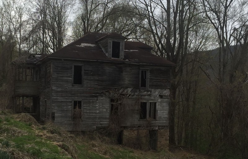
It is unfortunate the road is in such a state of disrepair, as tt is along this section of road a large two-story structure, probably a boarding house, stands. This structure dwarfs everything else in the immediate area. Not only is it two full stories tall, it is built into the hillside making it appear even larger. Mother Nature and neglect have degraded this building to a state beyond repair. The windows have been broken and there is at least one gaping hole in the roof giving this once grand building a haunted look. In a report for the National Parks Services, it is theorized the building was possibly a boarding house for the community. The adventurous tourist that wants to see this building before it is completely reclaimed by nature is advised to park at Little Rock Assembly Church and walk to the building. The road is not suitable for most vehicles.
Thayer’s economic heyday collapsed alongside most of the gorge’s coal mining in the mid-twentieth century. The final nail in the coffin for the coal town was the closure and cessation of post office operations in 1968. Today, Thayer is inhabited only by a handful of hearty souls that call this piece of history home. The company houses in near original condition along the bottom appear to remain in use as summer cabins. There are also a number of modern structures that appear to be in use as summer cabins and year-round residents. This area is also home to a spartan camping site managed by the National Parks Service. The community is located slightly more than seven miles upriver from Thurmond on McKendree Road, an improved dirt and gravel road. This road connects Thurmond to Prince fourteen miles upriver. In reality, this road becomes almost impassable just past Thayer. Even daily travel between Thayer and Thurmond would require a four-wheel drive vehicle. Travel to Thayer should be done only under the best of weather conditions.
Sources
Bragg, Melody. Thurmond and Ghost Towns of the New River Gorge. Glen Jean, WV. Gem Publications, 1995.
Cavalier, John. Panorama of Fayette County. Parsons, WV. McClain Print Company, 1985.
EDAW, Inc.. Riveranna Archaeological Services, LLC.. Jordan, Norman. Traditional Associations of African Americans with New River Gorge National River. 2009. Prepared for National Park Service; New River Gorge National River
Peters, J. T. Carden, H. B. History of Fayette County West Virginia. Charleston, WV. Jarrett Printing Company, 1926. Reprinted 1972 by McClain Printing Co. Parsons WV
"Western Wing and Personal Notes." The Black Diamond, vol. 31, no. 13. Published September 26, 1903. https://play.google.com/store/books/details?id=DyUzAQAAMAAJ.
Workman, Michael E. Maddex, Lee R. Bonenberger, Dan J. New River Gorge National River: Historic Resource Study NERI-02-038 HRS. WV. Institute for the History of Technology & Industrial Archaeology, 2005. Report submitted to New River Gorge National River US Dept. of Interior, National Park Service Cooperative Agreement No. H0001010032.
“Railroad Station, Thayer, W. Va.” West Virginia & Regional History Center. Accessed May 10th 2021. https://wvhistoryonview.org/catalog/052206.
“Crowd Gathered for Baptism by New River at Thayer, W. Va.” Circa 1920. West Virginia & Regional History Center. Accessed May 10th 2021. https://wvhistoryonview.org/catalog/044391.
“Coal Company Club House, Thayer, W. Va.” West Virginia & Regional History Center. Accessed May 10th 2021. https://wvhistoryonview.org/catalog/052205.