Wager Six Acre Reservation Lot
Introduction
Text-to-speech Audio
This part of Lower Town is known as the Wager Reservation Lot because it was part of the private land retained by the Wager family when the U.S. government purchased the surrounding land for the armory. This has been the residential and commercial center of Harpers Ferry for much of the town's history.
Images
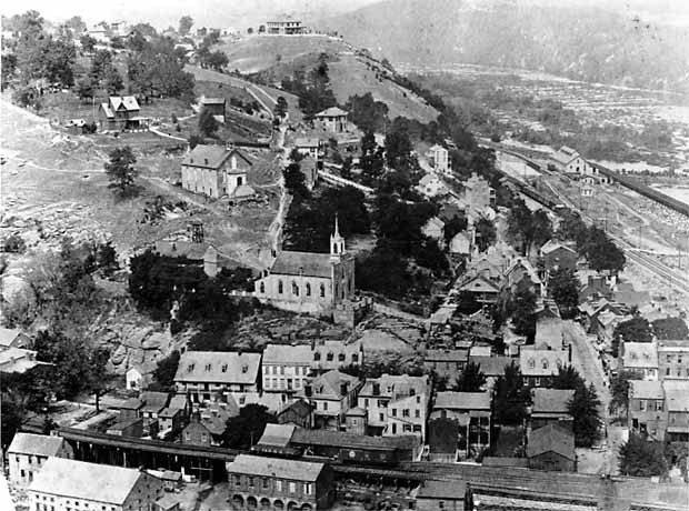
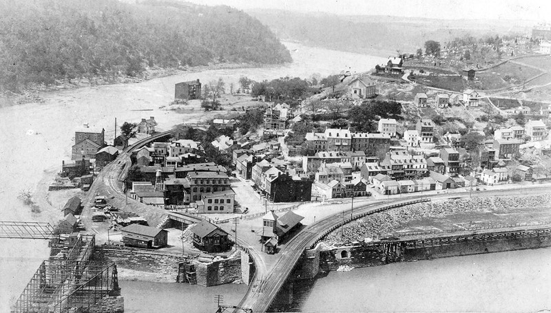
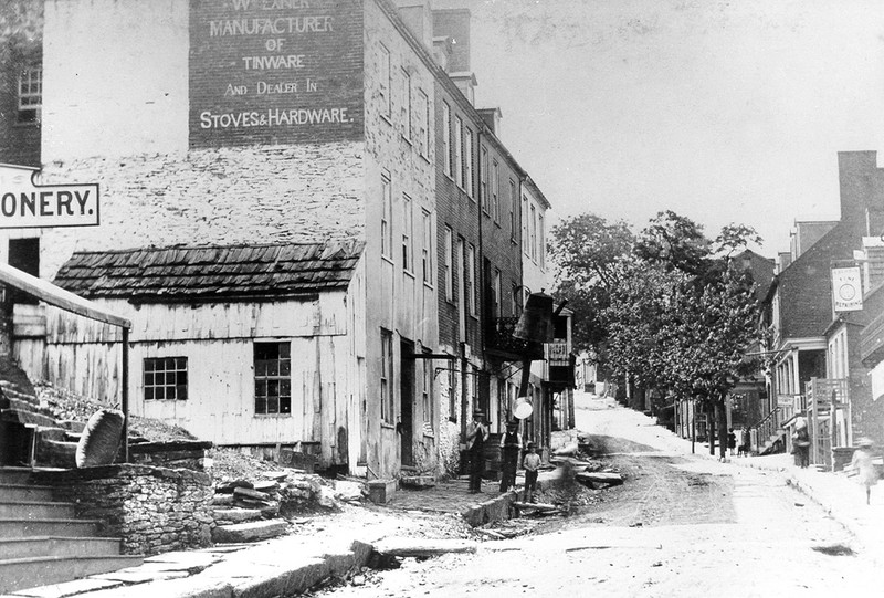
Harpers Ferry, c. 1895
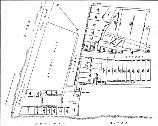
Plat map of the Wager Reservation Lot, 1835
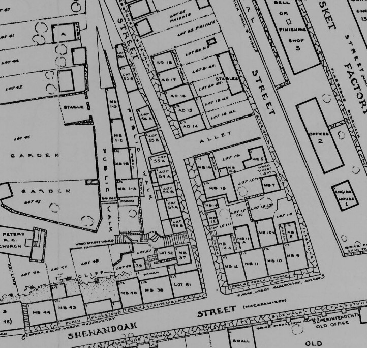
Wager Reservation Lots, Historical Base Map, 1859
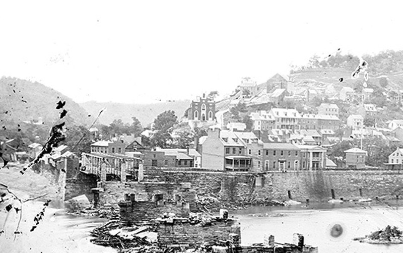
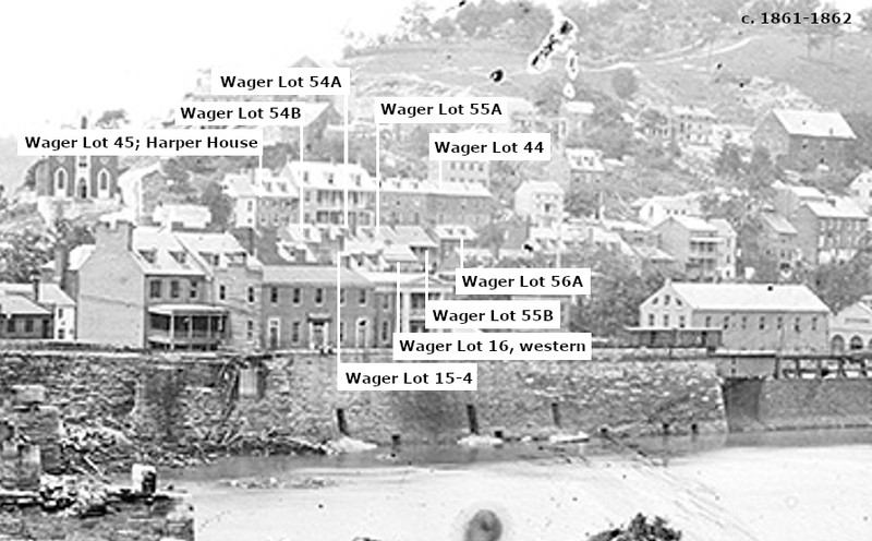
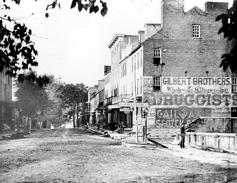
View of Harpers Ferry between June 14, 1861 when Confederates burned the B&O Railroad Bridge and February 1862 when Union soldiers burned the buildings at the Point (LC-B817-7649, Library of Congress)
Labeled section of 1861-1862 view of Harpers Ferry
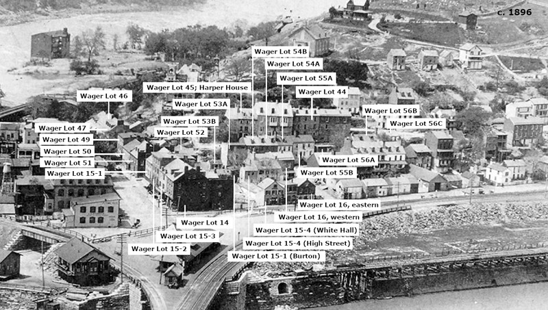
Lower Town in 1896 (HF-96, Historic Photo Collection, Harpers Ferry NHP)
Labeled 1896 view of Harpers Ferry.
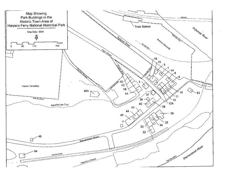
Map of NPS Building Locations and Numbers
c. 1889 view of Wager Lots 14 & 15 on Shenandoah Street (HF-1154, Historic Photo Collection, Harpers Ferry NHP)
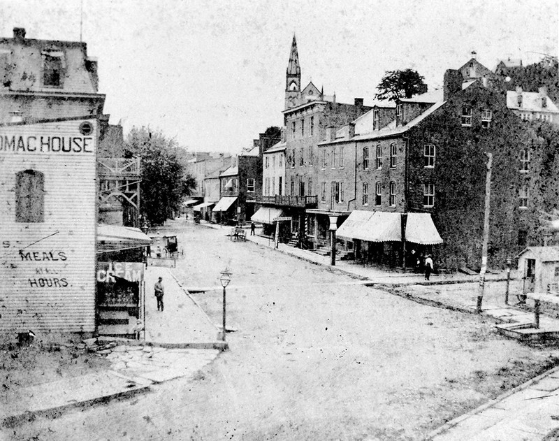
c. 1900 view of Shenandoah Street. Wager Lots 14 & 15 in the foreground with Wager Lots 51, 50, & 49 on the next block. The Potomac House on the left was on the grounds of Arsenal Square until the 1940s. (HF-1819, Historic Photo Collection, Harpers Ferry NHP)
Wager Lot 14; Park Buildings 8 & 9
Wager Lot 15-3; Park Building 10
Wager Lot 15-2; Park Building 11
Rear addition of Wager Lot 12-2; Park Building 11A
Wager Lot 15-1; Park Building 12
Wager Lot 51
Wager Lot 50; Park Building 38
Rear of Wager Lot 50; Park Building 39
Wager Lot 49; Park Building 40
Wager Lot 48
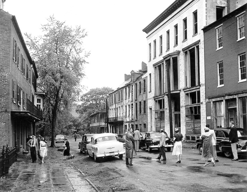
Shenandoah Street with buildings abandoned and in disrepair, May 1955. On the left is Armory Dwelling 2 (next to Arsenal Square). On the right Armory Dwelling 2 and Wager Lots 47, 46, & 49 are visible. The large white building is the department store that was constructed in Wager Lot 48 in 1898-99 and demolished in 1957. (HF-311, Historic Photo Collection, Harpers Ferry NHP)
Shenandoah Street, c. 1880 showing Wager Lots 46 & 47 (HF-446, Historic Photo Collection, Harpers Ferry NHP)
Wager Lot 47; Park Building 43
Wager Lot 46; Park Building 44
Wager Lot 15-2/4; Park Building 7
Wager Lot 16 (Potomac Street); Park Building 5
Wager Lot 16 (High Street); Park Building 16
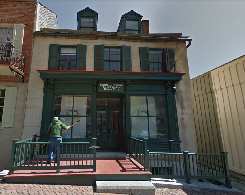
Wager Lot 15-4; Park Building 15
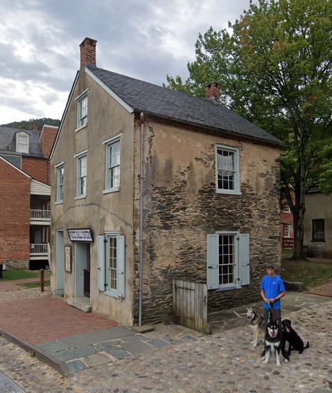
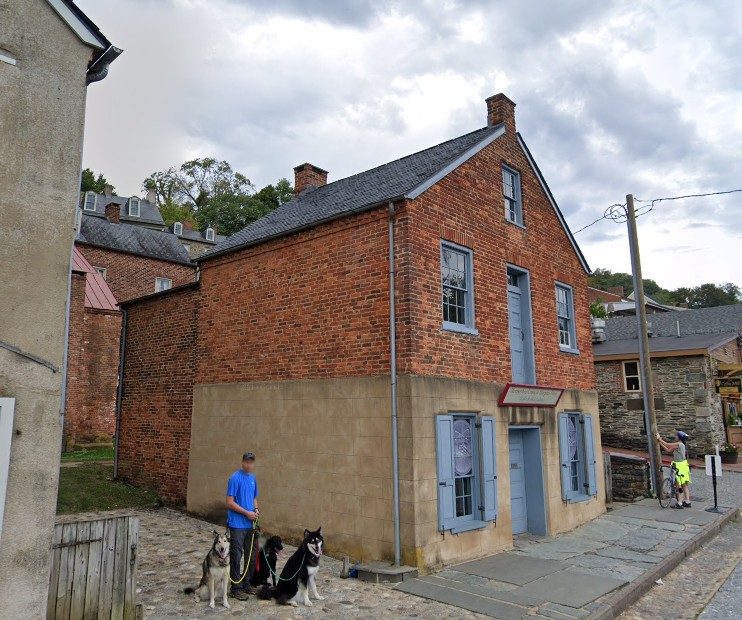
Wager Lot 15-1; Restored Burton's Store (Park Building 14) and foundation remains of second building
Wager Lot 52; Park Building 37
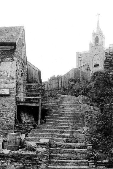
View up the stone steps, c. 1890-1892 (HF-94, Historic Photo Collection, Harpers Ferry NHP)
Wager Lot 53B
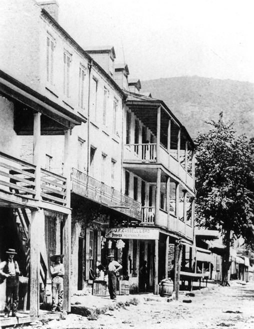
View up High Street, May 1886. Wager Lots 53A, 54B, 54A, & 55A are visible on the left. (HF-787, Historic Photo Collection, Harpers Ferry NHP)
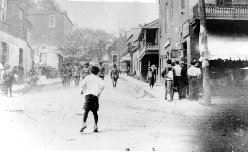
View up High Street, c. 1918 (HF-378, Historic Photo Collection, Harpers Ferry NHP)
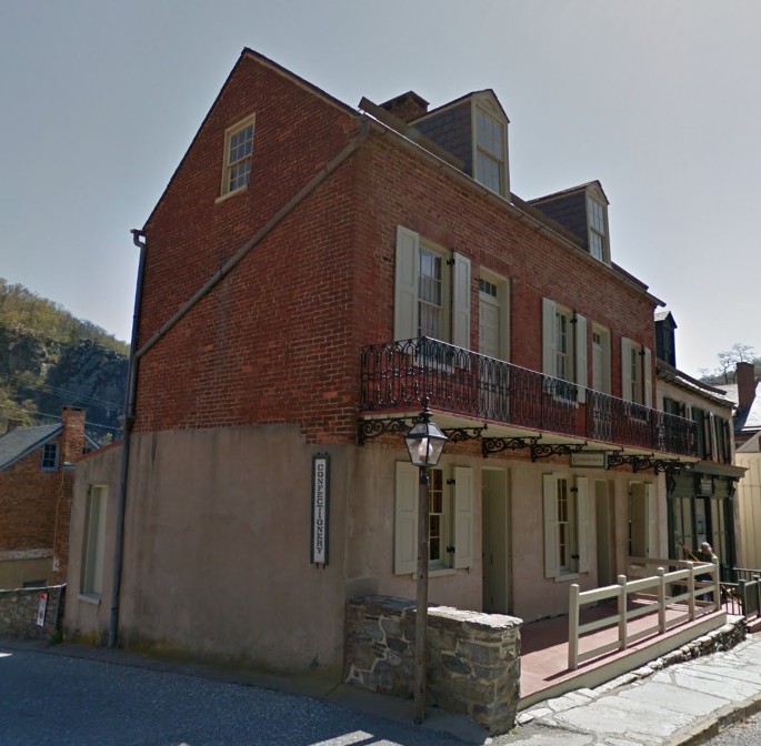
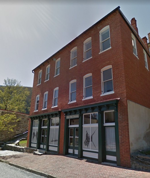
This c. 1900 building replaced the two original structures on Wager Lots 53A and 54B; Park Building 3
Wager Lots 54A through 56C on High Street
View down High Street on the left and Public Walk on the right, c. 1873 (HF-33, Historic Photo Collection, Harpers Ferry NHP)
.jpg)
View down High Street on the left and Public Walk on the right, c. 1930 (HF-280, Historic Photo Collection, Harpers Ferry NHP)
.jpg)
Wager Lot 44, Public Way View; Park Buildings 1B, 1C, & 1D
Wager Lot, Park Building 1D, High Street View
Wager Lot 44, Park Building 1C, High Street View
Wager Lot 44, Park Building 1B, High Street View
Wager Lot 45, the Harper House, Public Walk View; Park Building 1A
Wager Lot 45, the Harper House, High Street View; Park Building 1A
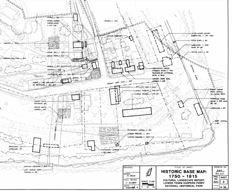
Lower Town, 1750-1815
Lower Town, 1815-1865

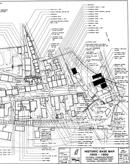
Lower Town, 1865-1900
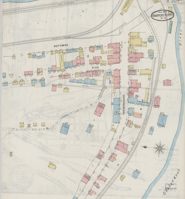
Sanborn Fire Insurance Map from Harpers Ferry, Jefferson County, West Virginia. Sanborn Map Company, Nov, 1894. Map.
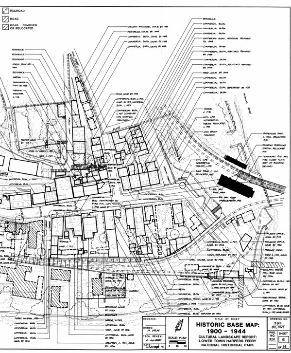
Lower Town, 1900-1944
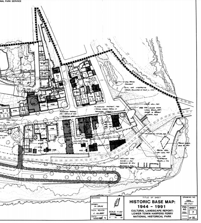
Lower Town, 1944-1991
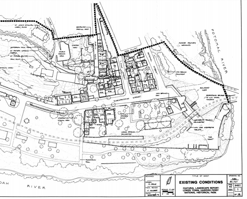
Lower Town, current conditions
Backstory and Context
Text-to-speech Audio
Robert Harper first arrived at the confluence of the Potomac and Shenandoah Rivers in 1747. He quickly purchased the land claim from its previous owner (Peter Stephens) and submitted a patent request to Lord Fairfax. Harper received a patent for 125 acres in 1751 and quickly built two mills, a tavern, and residential buildings. When Robert Harper died in September 1782 he willed the eastern portion of his land to his niece, Sarah Harper, and her husband, John Wager, Sr. (the western portion of his land, including Halls Island was granted to his nephew Robert Griffith).
During George Washington’s administration, Congress authorized the establishment of three federal armories. When Washington chose Harpers Ferry as one of the locations the United States government purchased approximately 427 acres from the Harper/Griffith lands. Robert and Sarah Wager and their heirs retained ownership of two tracts of land within Lower Town. The Wager Reservation was six acres in the center of what is now Lower Town, primarily along Potomac and High Streets. As the Federal Armory expanded around the Wager Reservation, the private land developed as the commercial and residential center of town. Once the more flat and accessible parcels of land were developed, buildings and gardens were constructed into the steep hillsides. The Wager family dominated the town until 1834 when James Bates Wager went bankrupt and more people were able to individually own property.
With the expansion of industry in Harpers Ferry and the arrival of the railroads, the town boomed from the 1830s to the Civil War. As Harpers Ferry grew the Wager Reservation lot filled in with more homes and commercial buildings as parts of the cliffs were blasted away to make room for development. Unfortunately, the Civil War brought incredible destruction to Harpers Ferry. With the town constantly in the path of both Union and Confederate forces, the armory buildings and bridges were destroyed and rebuilt several times, the buildings at the point were burned down, and nearly every structure in Lower Town had some damage by the end of the war.
After the Civil War the U.S. Government abandoned the armory site and sold the government land holdings into private ownership. There was a resurgence of industry with the Harpers Ferry Paper Mill and McGraw bottling business in the late 1800s. However, while the Lower Town rebuilt as a commercial center, Harpers Ferry was never as economically prosperous as prior to the war. Increasingly damaging floods and the decline of the industrial areas limited the recovery of the town in the late-nineteenth and early-twentieth centuries. Transportation and services catering to travelers remained important with the B&O Railroad, highway bridges, and—after1937—new Appalachian Trail all converging on the Point at Harpers Ferry. Tourism became increasingly vital to the economy of the town as visitors came to see the natural beauty of the area and see the site of John Brown’s raid.
In 1944 Congress authorized a national monument at Harpers Ferry of 1500 acres to preserve and commemorate the history of the town and its events. This was enlarged in 1963 to 2500 acres as Harpers Ferry National Historical Park and additional acreage was placed under the NPS administration through 1980. By the time the NPS acquired Harpers Ferry, Lower Town was in poor condition due to major floods and economic decline. As a result, in the 1950s through 1970s the NPS removed any postwar structures to focus interpretation on the period 1859-1865 (John Brown’s Raid and the Civil War) and restored the damaged historic structures that dated from that period. This allowed the National Park Service to create an interpretive space to present 1859-1865, but also left large empty spaces in the landscape.
Descriptions of historic buildings from the 1980 National Register of Historic Places Nomination:
North Side Shenandoah Street:
Wager Lot No. 14: “contained a 3-1/2-story brick building with cellar and slate roof erected by Michael Foley in 1837-38 (Park Bldg. No. 9). It fronted 29-1/4’ on Shenandoah Street and was 40’ deep along Potomac Street. The first floor contained a store and the upper floors were used for living quarters. In 1841-42 John O’Hara erected a 2-1/2-story brick annex at the rear (Park Bldg. No. 8). Measuring 16’ wide by 29’ long, this addition had a roof with two dormers pitching steeply to the west and a two-story frame porch on the west. It probably contained a kitchen and pantry and bedrooms on the upper floors. The house was probably occupied in 1859 as the dry goods store and residence of John G. Ridenour. The National Park Service reconstructed Buildings 9 and 8 to their antebellum exterior appearance in 1978-79. A store front of cast iron, wood, and stamped sheet metal added to the first floor of Building 9 shortly before 1896 was removed to reconstruct the original store front.”
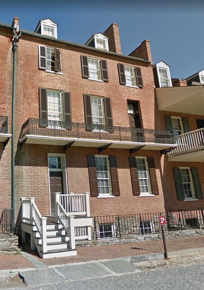
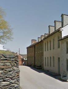
Wager Lot No. 15, Subdivision No. 3: “contained two adjoining brick buildings erected by Philip Coons in 1846-47. That fronting Shenandoah Street (Park Bldg. No. 10) had 2-1/2 stories, a cellar, and a slate roof. It fronted 28’2” on Shenandoah Street and was 40’10” deep. A large covered two-story frame porch and two dormer windows faced the street, and a large glass skylight was on the opposite (north) side of the roof. In 1859 the first floor was occupied by Nisan Frank’s ready-made clothing store. Attached at the rear was a two-story structure, 25’ wide and 36-1/2’ deep, with a slate roof and no cellar (Park Bldg. No. 10A). The west wall contained two chimneys each serving two fireplaces. The first floor was probably used as a warehouse or counting room in connection with the store in the main building. The second floor probably contained a kitchen, pantry, and extra space for the dwelling portion of the main building. In 1859 the upper floors of both buildings were occupied as a boardinghouse operated by Fanny J. Butter. After the Civil War a third story and attic were added to the main building, its front porch was removed, and its first floor store windows were enlarged. In 1978-79 the National Park Service reconstructed the exteriors of the building to their antebellum appearance.”
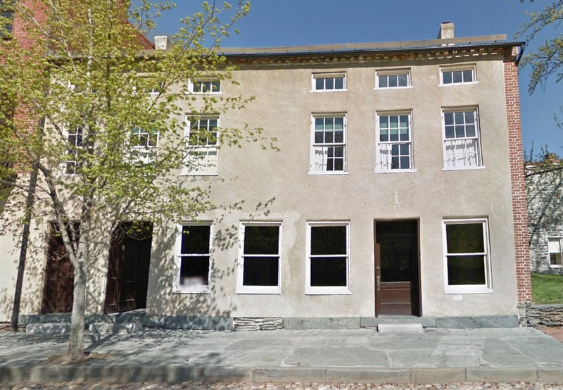
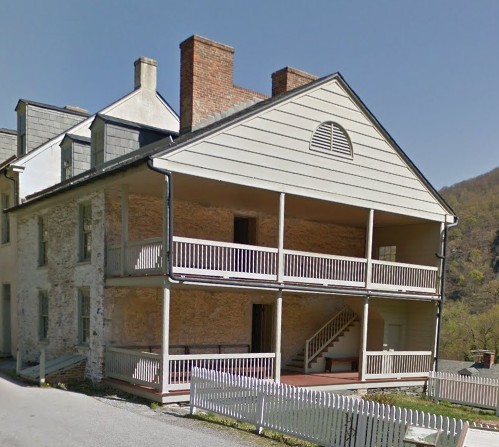
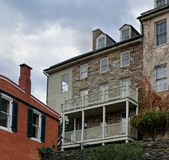
Wager Lot No. 15, Subdivision No. 2: “contained a 3-1/2-story brick building with cellar and slate roof erected by William Anderson and Ann C. Stephenson in 1838-39. It fronted 32’ on Shenandoah Street and was 40’10” deep. An iron balcony ran along the street front at the second floor level of this structure (Park Bldg. No. 11). A two-story brick wing, 19’5” by 32’11” with slate roof, was added to the rear by William Anderson between 1840 and 1845 (Park Bldg. No. 11A). The first floor of the main building contained a store, with a small kitchen and cold storage room in the addition. The upper floors of the main building included nine rooms, six with fireplaces, and a pantry. The second floor of the wing contained a kitchen and pantry designed for use in conjunction with the dwelling portion of the main building. The buildings were occupied as the dry goods store and residence of Charles Johnson in 1859. The upper floors of the main building were damaged during the Civil War, after which Daniel Ames, the new owner, added a full story in place of the original half floor. Around the turn of the century a new storefront with large windows was added and the interior was converted to lodging rooms and apartments. In 1971 the National Park Service removed the fourth floor, and in 1978-79 it completed exterior restoration of the building to its antebellum configuration.”
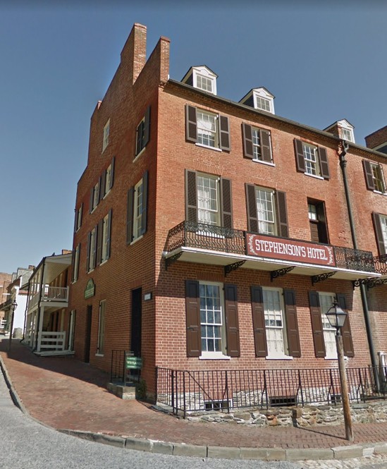
Wager Lot No. 15, Subdivision No. 1: “contained a 3-1/2-story brick building with cellar and slate roof erected by William Anderson and Ann C. Stephenson in 1838-39 (Park Bldg. No. 12). It fronted 28’ on Shenandoah Street, having an iron balcony at the second floor level, and extended back 40’10” along High Street. The first floor contained a store; the living quarters above probably contained nine rooms, six with fireplaces, and a pantry. Between 1840 and 1845 Ann Stephenson added a two-story brick wing with cellar fronting on High Street at the rear (Park Bldg. No. 12A). The addition ran 28’8” on High Street and extended back 23’7”. The first floor may have originally contained a small shop and the second floor a kitchen and pantry. In 1859 the main building was occupied as the dry goods story and residence of George W. Taylor; Ann Stephenson then resided in the wing or part of the main building. Around the turn of the century large story display windows and a corner door were added to the first story of the main building. In 1978-79 the National Park Service reversed these modifications in restoring the building exteriors to their antebellum appearance.”
Wager Lot No. 51: “on the northwest corner of Shenandoah and High street, contained a 2-1/2-story brick building with cellar and slate roof erected by William and Samuel B. Anderson in 1832. The building fronted 43’ on Shenandoah Street and was 35’ deep along High Street. A two-story brick annex about 14’ by 12’ was added to the rear between 1840 and 1845. The first floor of the main building contained a large story and the upper floors included nine rooms, four with fireplaces. The annex contained a kitchen and meat house. In 1859 the property was owned by Noah H. Swayne and occupied as the dry goods store and residence of Fayette J. Conrad. In 1894 the building contained a grocery store. It was demolished c. 1921 for the construction of a gasoline station on the lot. The station was removed prior to 1954 and the lot remains vacant.”
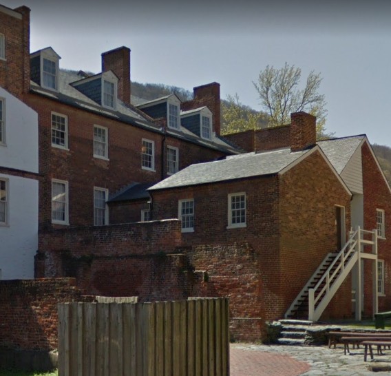
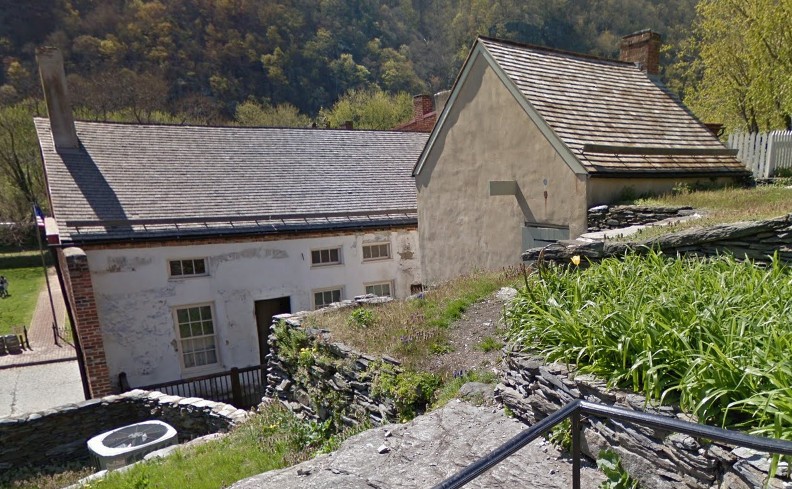
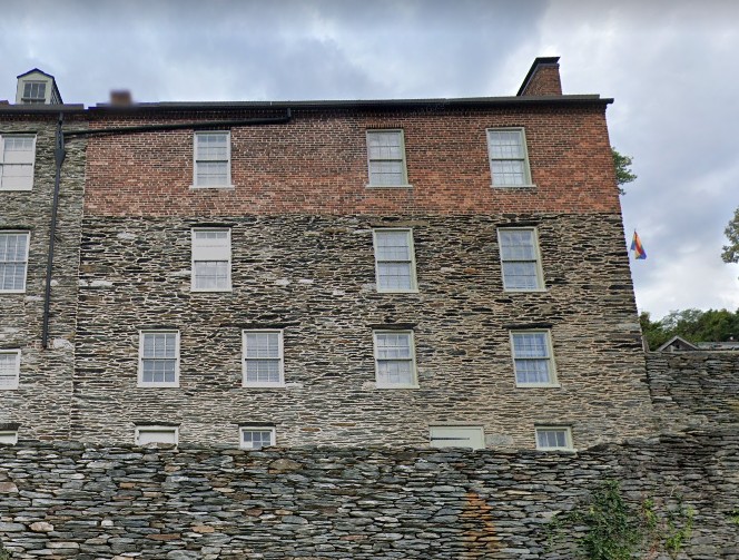
Wager Lot No. 50: “contains a 2-1/2-story stone building with no cellar and a wood shingle roof constructed in 1844 (Park Bldg. No. 38). It fronts 41’9” on Shenandoah Street and is 30’ deep. A two-story frame porch extends across the rear. A four-foot-wide alley in the center of the first floor led through the building to the rear.* The divided first floor contained two shops, and the upper floors had two sets of living quarters with six rooms each. In 1859 the west half was occupied as the butcher and grocery store and residence of Michael Tearney. The living quarters over the other shop were then occupied by Bernhard Hirsh, who operated a store on Wager Lot No. 49. A small two-story stone structure about 14’ by 16’ was erected in the rear between 1844 and 1861 (Park Bldg. No. 39). It may have served as a warehouse for the stores or as a kitchen and smoke house for the residences in the main building. It now houses electrical transformers. The exteriors of both buildings are little altered. Recent archaeological investigations on Wager Lot No. 50 have revealed the foundations of an 18th century structures, possible a stable, within Park Bldg. 38. These early remains are currently exposed for interpretation to the public.
*Now blocked on façade by window with stone infill below.”
Wager Lot No. 49: “contained a two-story stone building erected by Daniel A. Weed in 1814 (Park Bldg. No. 40). The building, which fronted 32’8” on Shenandoah Street and was 34’4” deep, had a cellar, a wood-shingled gable roof, and a large two-story frame porch extending out over the sidewalk. The first floor contained a large store and the second floor three rooms used as living quarters. In 1859 Philip Frankel & Company’s Ready-Made Clothing Store occupied the first floor while William Richards, owner of the property, lived above. During the Civil War the building was burned out and its gable roof and front porch were destroyed. After the war it was rebuilt with brick second and third stores and a flat roof. Around 1900 larger display windows were installed on the ground floor. The building currently exists in its modified form.”
Wager Lot No. 48: “originally contained a two-story stone building with wood-shingled gable roof probably erected by John Wager, Jr., between 1803 and 1813. It fronted about 37’ on Shenandoah Street and was 17’ deep. The first floor contained one store and the second floor contained living quarters. Between 1835 and 1861 a two-story addition approximately 12’ square was constructed on the east end of the building, extending it across the entire front of the lot. In 1859 the building probably contained David Whip’s tailor shop or John Legg’s shoemaker shop. Between 1864 and 1894 the building was demolished. In 1898-99 much rock was blasted from the high cliff at the rear of the lot to provide space for the erected of a large three-story stone department store (Park Bldg. No. 41). This and another later structure (Park Bldg. No. 42) were demolished by the National Park Service in 1957. Removal of the department store revealed the still-present ghosts of the c. 1813 building on the side walls of flanking Park Bldgs. 40 and 43. The lot remains vacant.”
Wager Lot No. 47: “contains a 3-1/2-story stone building constructed by Nicholas Marmion and Martin Graco in 1845. Fronting 40’ on Shenandoah Street and measuring 31’4” deep, the building has no cellar, a large three-story covered frame porch across its façade, and a slate gabled roof with four front dormers. It was originally divided by a central brick wall running on the lot subdivision line; each half contained a store on the ground floor and living quarters above. In 1859 Nicholas Marmion owned the west half, the heirs of Frances McCabe owned the east half, and James McGraw operated a grocery and liquor store and a fish market in the first floor stores. A 2-1/2-story stone annex behind the west half probably contained kitchens and pantrys (sic) for the main building. A fire gutted the east half of the building in 1949, by which date the front porch had disappeared. The interior brick party wall collapsed following severe weather in 1960, which so damaged the front wall that it had to be taken down and rebuilt. In 1973 new doors, sash, and frames of antebellum design were installed, and in 1975-76 the front porch was reconstructed, largely restoring the exterior to its antebellum appearance. The interior is wholly undivided. (Park Bldg. No. 43)”
Wager Lot No. 46: “contains what was originally a two-story stone house fronting 38’ on Shenandoah Street and measuring 32’ deep (Park Bldg. No. 44), erected by Philip Coons in 1845-46. There was no cellar; the first floor was divided by a brick partition into two stores; the second floor contained five rooms and was designed for use as a dwelling. In 1845-46 a stone third floor and a slate roof were added by the Masonic Order of Harpers Ferry. A wooden exterior stair at the west end provided access to the third floor, which contained a large meeting room and a smaller room. In 1859 one of the stores (probably that on the west) and the second floor quarters were occupied by John N. Stonebraker as his bakery and residence. The other shop, vacant that October, had previously been occupied by William Newton’s grocery and butcher shop. The third floor housed the Masonic Hall of Charity Lodge No. 11. William Richards, owner and resident of Wager Lot 49, then owned the property. The National Park Service has restored the exterior of the building to its 1859-65 appearance while adapting the interior to contemporary uses.
Wager Six Acre Reservation—High and Potomac Streets
Wager Lot No. 15, Subdivisions No. 2 and 4: “originally contained a one-story stone building measuring 24’ by 40’ with cellar and slate roof, erected by William Anderson in 1838-39. Between 1847 and 1852 Frederick A. Roeder added a second stone story. In 1856 the front part of the building was removed for the widening of Potomac Street, reducing its depth to 20’. The street façade was rebuilt with brick for the second story and gable end. The first floor was a tavern called “White Hall” for most of the years from 1848 to 1953. In 1859 John Fitzpatrick, a stonecutter, probably occupied the residential quarters on the second floor. In 1861-62 the structure (now Park Bldg. No. 7) was used by the Union Army as a stable.”
Wager Lot No. 16: “The eastern part of Wager Lot No. 16 facing Potomac Street contains a two-story building constructed by Frederick A. Roeder in 1856-57 (Park Bldg. No. 5) to replace the space lost when his building next door (Park Bldg. No. 7) was shortened. In dimensions and materials, the structure was a near-twin of its truncated neighbor. It had no cellar, however, and by 1861 a two-story brick wing with a slate-covered shed roof, 12’7” by 13’, was added to its rear. The building was variously used as a tavern, store, and warehouse, and was also occupied by the Union Army as a stable in 1861-62. Bldgs. 5 and 7 stand today in essentially their Civil War configurations.
The western part of Wager Lot No. 16 facing High Street contains what was originally a two-story stone structure, fronting 22’ on High Street and measuring about 17-1/2’ deep, built by Frederick A. Roeder in 1844 (park Bldg. No. 16). Because of the sloping terrain, the first story was above ground at the rear but below grade on High Street, so that an areaway on that elevation provided direct access to the second floor. In 1848-49 Roeder extended the building with a stone addition about 13’ to the north (or northwest), bringing the structure to its present plan dimensions of about 35’ by 17-1/2’. The rubble stone walls were pargeted. In 1856-57 a brick story-and-a-half was built atop the existing stone walls. An ornamental cast iron balcony was installed across the High Street façade at the juncture of the stone and brick, and a covered two-story frame porch extended across the rear. Before 1859 a two-story brick structure, about 14’ by 11’, was erected at the outer edge of the rear porch on the south side of the lot (Park Bldg. No. 16A). The main building was the residence and probably the shop of Roeder, a confectioner, from 1845 to 1861. It housed troops during the Civil War and continued in residential use until 1953. Its exterior has been largely restored to its Civil War appearance.”
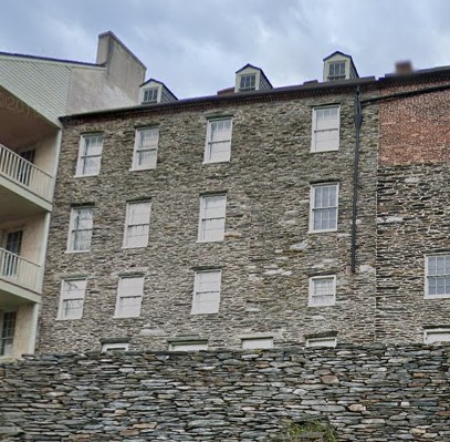
Wager Lot No. 15, Subdivision 4: “facing High Street contains a 2-1/2-story stone structure erected by William Anderson in 1838-39 (Park Bldg. No. 15). The building fronts 24’ on High Street and measures 40’8” deep. The full basement beneath is wholly above grade at the rear. Projecting from the east end of the south elevation is a 1-1/2-story stone wing, which is the remaining two-thirds of an earlier structure on the site possibly dating from 1803. Construction of the 1838-39 building caused destruction of the western third of this structure and conversion of the remainder to a kitchen wing of the new building, measuring about 15’ square. A frame second story and attic was added to the wing probably in the decade after the Civil War. Between 1894 and 1907 a two-story covered frame porch and enclosed stairway was built along the south elevation abutting the raised kitchen wing. At approximately the same time a storefront with larger display windows and a covered one-story porch were added to the High Street façade. For most of the period 1839-1952 the building contained a small shop in the first floor room on High Street and dwelling rooms rented to one or more families. The National Park Service has removed the frame porches and addition atop the kitchen wing while retaining the turn-of-the-century storefront. (The building is commonly known as the Susan Downey House for its ownership by Mrs. Downey and her heir from 1846 to 1868).”
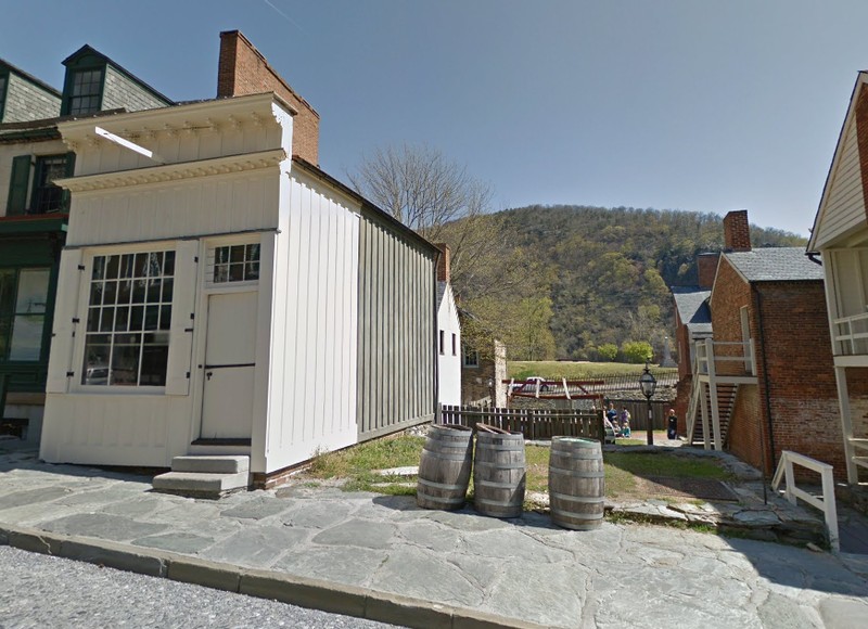
Wager Lot No. 15, Subdivision 1: “The northwest corner of Wager Lot No. 15, Subdivision 1, contained a one-story frame building on a low brick foundation erected by Alfred Burton in 1857. The one-room building, occupied by Burton’s jewelry store, fronted 11’10” on High Street and was 20’5” deep. The National Park Service disassembled and stored the façade and side elements of the little-altered structure in 1956 to preserve it while restoration work proceeded on neighboring buildings. Its ultimate reassembly is planned. (Park Bldg. No. 14).
To the right of Burton’s store on the same lot subdivision was another one-story frame shop probably erected in 1850 by Ann C. Stephenson. It fronted 21’ on High Street and was about 15’ deep. In 1859 it contained either a shoemaker’s shop or a small grocery store. Between 1886 and 1890 it was completely rebuilt. In 1956 the National Park Service demolished the rebuilt structure (Park Bldg. No. 13). Foundation remains are present onsite.”
Wager Lot No. 52: “on the west side of High Street one lot up from the corner of Shenandoah Street, contains a two-story stone building probably constructed by John Wager, Jr., between 1803 and 1813 (Park Bldg. No. 37). The building originally had a wood-shingled gable roof, fronted 29’4” on High Street, and was about 18’ deep. The first floor contained one store and the second floor contained living quarters. By 1844 a small frame 1-1/2-story kitchen, approximately 22’ by 15’, projected from the north part of the rear elevation at its second floor level, as the building backed against a hill. In 1859 the building was occupied by John T. Rieley as his boot and shoe making shop and residence. About 1900 the front wall was advanced about eight or nine feet to the edge of the sidewalk. The gable roof was then replaced by a flat roof pitched slightly rearward behind a straight bracketed cornice across the top of the façade. The new front wall contained larger store display windows, and the first floor was lowered about four feet to match the level of the sidewalk. The kitchen wing was removed. The building remains as modified.”
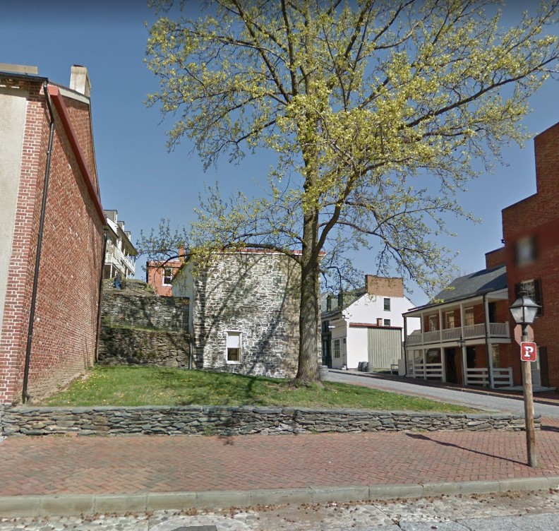
Wager Lot No. 53B: “on the north side of the stone steps across from Lot 52, contained a one-story frame house erected by William Moore between 1845 and 1848. It fronted about 19’ on High Street and measured about 18’ deep. The building was demolished prior to 1954, and the lot is now vacant.”
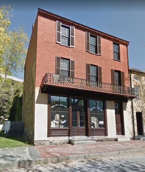
Wager Lot No. 53A: “originally contained a 3-1/2-story stone building erected by Samuel M. Williams about 1849. The structure fronted about 28’ on High Street and was about 20’ deep, with an areaway about nine feet wide between the rear wall and the cliff behind. The exterior walls of the first two stories were pargeted. The building was demolished prior to 1900. Adjoining Wager Lot No. 54B originally contained a 3-1/2-story brick building erected by Michael Doran in 1849. This building fronted about 20’ on High Street and was about 21’ deep, with a one-story porch at the rear. It was demolished between 1894 and 1900. Between these dates the existing three-story brick building on Lots 53A and 54B was constructed. It fronts 41’ on High Street and abuts the cliff at the rear of the lot some 33’ back. The façade has two storefronts, segmental-arched windows above, and a brick dentil cornice at the edge of a nearly flat roof. The third floor opens to a terrace on the cliff at the rear. The first floor is currently used for storage and the upper floors for living quarters. (Park Bldg. No. 3).”
Wager Lot No. 54A: “originally contained a 3-1/2-story brick building with gable roof erected by George W. Cutshaw in 1839. The building fronted approximately 21’ on High Street and was about 20’ deep. The first floor contained Cutshaw’s tailor shop and the upper floors his living quarters. By 1893 this structure had been demolished and replaced by a two-story frame building that fronted 19’ on High Street and was 23’ deep. The National Park Service demolished this Park Bldg. No. 2 in 1956. Only the ruins of fireplaces in the rear wall of the first house, built up against the face of the cliff, are now visible on the lot.”
Wager Lot No. 55A: “contained a three-story brick building erected by John A. Gibson in 1848. The structure fronted 22’ on High Street and was about 28’ deep. Until 1856 it was an oyster house and tavern known as the Green House. In 1859 it was apparently rented as a dwelling by William Small, a carpenter, and James Wigginton, a laborer. It was demolished in the 1930s, and the lot remains vacant.”
Wager Lot No. 55B: “contained a three-story stone building probably erected by the Wager family prior to 1835. The structure fronted about 32’ on High Street and was about 22’ deep. It was in ruins in the 1920s and was demolished prior to 1954.”
Wager Lot No. 56A: “originally contained a 3-1/2-story brick building with gable roof erected by Abraham Fleming in 1841. The structure was about 20’ square in plan. The first floor contained two shop rooms and the upper floors were residential. In 1859 the building was probably the saddle and harness making shop and home of John Whip. A two-story brick wing with gable roof about 10’ wide and 20’ deep extended from the north side of the main building. The entire structure was demolished between 1886 and 1894 and was replaced by a long two-story frame building containing a stove store. The later structure disappeared in the 1930s, and only traces of fireplaces in the rear wall of the original building, set against the cliff, are now visible.”
Wager Lot No. 56B: “contained a 2-1/2-story brick building with gable roof probably erected by Gerard B. Wager between 1842 and 1848. The structure fronted approximately 36’ on High Street and was 18’ deep. A two-story frame porch extended across the façade. In 1859 the building was owned by Wager’s estate and was probably occupied by John McCall. In the 1930s ruins of the then-abandoned building were still standing, but there were demolished prior to 1954. Only traces of the rear wall, located against the cliff, are now visible.”
Wager Lot No. 56C: “contained a three-story brick and stone structure with gable roof probably erected by Gerard B. Wager between 1843 and 1848. The building fronted 30’ on High Street and was 17’ deep at its south end and 12’ deep at its north end. A two-story porch ran across the façade, and a two-story, two-bay-wide stone wing extended to the north. In 1859 the property was owned by the estate of Gerard Wager and occupied by Thomas Boerly as his residence and tavern. The wing was in ruins by 1870 and the main structure was ruinous by the 1930s. The whole was demolished prior to 1954, and only traces of the rear walls against the cliff are now visible.”
Wager Six Acre—Marmion Way
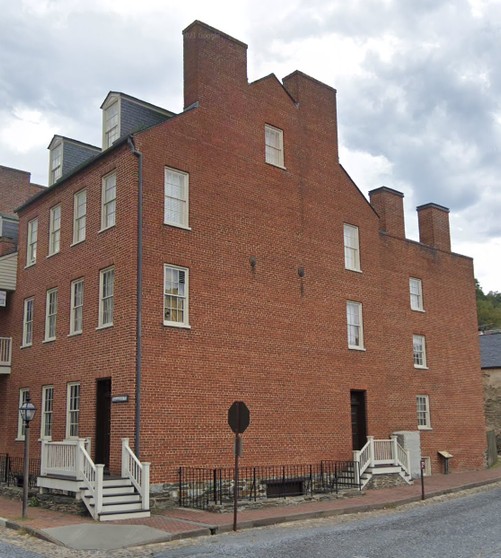
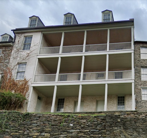
Wager Lot No. 44: “contains three abutting structures on the east side of Marmion Way. The southernmost (Park Bldg. No. 1B, Marmion Hall), measuring 45’ by 35’, is a 2-1/2-story pargeted brick building with wood-shingled gable roof erected by James B. Wager in 1832-33. The full basement is above grade on the east front. The north four of the five bays on that side are recessed, and a tiered frame porch (reconstructed in 1957) fills the recess. The door on the west front is at the southernmost of the five bays. Two end chimneys and an internal one pierce the ridge, and each side of the roof contains three dormers. The building was owned and occupied by Dr. Nicholas Marmion in 1859 and has been restored to its external appearance at that time. The central structure (Park Bldg. No. 1C, the Second Marmion Tenant House) is a stone house of 2-1/2-stories erected before 1848. A basement and cellar are exposed at the rear. This building was built in two parts, that on the south three bays wide and that on the north two bays wide, each with its own doorways. It has two interior chimneys and three dormers on each side of the roof. The house measures 39’5” long, 20’ wide at the north end, and 25’3” wide at the south end. The northernmost (Park Bldg. No. 1D, the First Marmion Tenant House) structure, also erected before 1848, aligns with its neighbor in height front and rear. Its walls are stone up to the top story, which is brick. It measures 44’5” long, 20’ wide at the south end, and 15’3” wide at the north end. It has two entrances on each façade and chimneys at each end of its gable roof. The latter two buildings were owned and rented out by Nicholas Marmion in 1859, the period to which their exteriors have been restored. On the western portion of Lot 44 across Marmion Way was a stone and frame stable (not extant) and a vegetable garden with stone retaining walls, first developed by James B. Wager in 1832-33. An icehouse built into the hill at the west edge of this open area remains.”
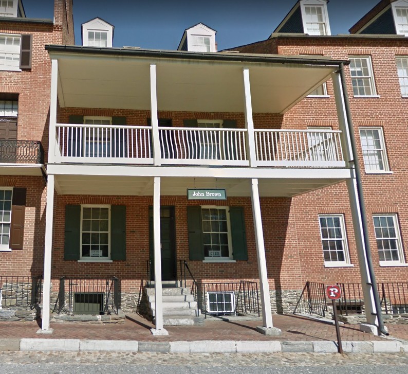
Wager Lot No. 45: “contains a 2-1/2-story stone building erected by Robert Harper as a tavern in 1775-82 and remodeled by James B. Wager in 1832-33 (Park Bldg. No. 1A, the Harper House). Its underlying stone basement and cellar are above grade on the east side of the structure, which measures 35’ by 25’. An open frame porch on the columns projects from the east side above the cellar level, and a large two-story frame porch covered by the structure’s roof forms the south end of the house. A bridge from the second floor of the latter porch crosses Marmion Way to the garden area on the western portion of the lot, first developed by James Wager in 1832-33. The stone structure is three bays wide and has two dormers on each side of its wood-shingled gable roof. The Harper House is the oldest standing building in Harpers Ferry. Until 1803 it was a tavern, where Thomas Jefferson probably stayed when he visited the town in October 1783 and George Washington stayed in 1785. From 1803 to 1836 it was the residence of the powerful Wager family, which held a monopoly of all privately owned land in the town from 1782 to 1836. From 1832 to about 1847 it and the adjacent Marmion Hall formed a unit; in 1847 they were subdivided to form two separate dwellings. In 1859 the Harper House was owned by Noah H. Swayne and rented as a tenement to two or three families. In 1957-61 the National Park Service restored both the exterior and interior to their 1859-65 appearance, which required reconstruction of the porches. The building is currently open as a furnished house exhibit.”
Sources
“Cultural Landscape Report: Lower Town, Harpers Ferry National Historical Park.” Harpers Ferry National Historical Park. National Park Service. Accessed August 13, 2021. https://irma.nps.gov/DataStore/Reference/Profile/28850.
"National Register of Historic Places Inventory--Nomination Form: Harpers Ferry National Historical Park." Accessed August 12, 2021. http://www.wvculture.org/shpo/nr/pdf/jefferson/66000041.pdf.
"St. Peter's Church & Rectory Lower Town, Harpers Ferry, circa 1895." History of St. Peter's Church. Accessed August 16, 2021. http://www.histarch.illinois.edu/harper/hf-0099.html.
"Cultural Landscape Report: Lower Town: Harpers Ferry National Historical Park." National Park Service. Accessed August 15, 2021. https://irma.nps.gov/DataStore/DownloadFile/559292.
"Harpers Ferry Historical Base Map, 1859, Part of the Master Plan, Harpers Ferry National Historical Park." Accessed August 16, 2021. http://npshistory.com/publications/hafe/map-1859.pdf.
"Baltimore & Ohio Railroad Bridges." Dave Gilbert Graphic Design. Accessed August 16, 2021. http://www.dgilbert53.net/?page_id=871.
"Baltimore & Ohio Railroad Bridges." Dave Gilbert Graphic Design. Accessed August 16, 2021. http://www.dgilbert53.net/?page_id=871. Edited by Kathleen Thompson.
"Lower Town." Dave Gilbert Graphic Design. Accessed August 16, 2021. http://www.dgilbert53.net/?page_id=448.
"Lower Town." Dave Gilbert Graphic Design. Accessed August 16, 2021. http://www.dgilbert53.net/?page_id=448. Edited by Kathleen Thompson.
Moyer, et al. "'To Preserve the Evidences of a Noble Past': An Administrative History of Harpers Ferry National Historical Park." Catoctin Center for Regional Studies, Frederick Community College, and Center for Heritage Resource Studies, Department of Anthropology, University of Maryland, 2004. Accessed October 18, 2021. http://npshistory.com/publications/hafe/adhi.pdf.
"Lower Town." Dave Gilbert Graphic Design. Accessed August 13, 2021. http://www.dgilbert53.net/?page_id=448.
"Lower Town." Dave Gilbert Graphic Design. Accessed August 13, 2021. http://www.dgilbert53.net/?page_id=448.
Google Maps. Accessed August 13, 2021.
Google Maps. Accessed August 13, 2021.
Google Maps. Accessed August 13, 2021.
Google Maps. Accessed August 13, 2021.
Google Maps. Accessed August 13, 2021.
Google Maps. Accessed August 13, 2021.
Google Maps. Accessed August 13, 2021.
Google Maps. Accessed August 13, 2021.
Google Maps. Accessed August 13, 2021.
Google Maps. Accessed August 13, 2021.
"Lower Town." Dave Gilbert Graphic Design. Accessed August 13, 2021. http://www.dgilbert53.net/?page_id=448.
"Lower Town." Dave Gilbert Graphic Design. Accessed August 13, 2021. http://www.dgilbert53.net/?page_id=448.
Google Maps. Accessed August 13, 2021.
Google Maps. Accessed August 13, 2021.
Google Maps. Accessed August 13, 2021.
Google Maps. Accessed August 13, 2021.
Google Maps. Accessed August 13, 2021.
Google Maps. Accessed August 13, 2021.
Google Maps. Accessed August 13, 2021.
Google Maps. Accessed August 13, 2021.
"Lower Town." Dave Gilbert Graphic Design. Accessed August 15, 2021. http://www.dgilbert53.net/?page_id=448.
Google Maps. Accessed August 13, 2021.
"Lower Town." Dave Gilbert Graphic Design. Accessed August 13, 2021. http://www.dgilbert53.net/?page_id=448.
"Lower Town." Dave Gilbert Graphic Design. Accessed August 15, 2021. http://www.dgilbert53.net/?page_id=448.
Google Maps. Accessed August 13, 2021.
Google Maps. Accessed August 13, 2021.
"Lower Town." Dave Gilbert Graphic Design. Accessed August 15, 2021. http://www.dgilbert53.net/?page_id=448.
"Lower Town." Dave Gilbert Graphic Design. Accessed August 15, 2021. http://www.dgilbert53.net/?page_id=448.
Google Maps. Accessed August 13, 2021.
Google Maps. Accessed August 13, 2021.
Google Maps. Accessed August 13, 2021.
Google Maps. Accessed August 13, 2021.
Google Maps. Accessed August 13, 2021.
Google Maps. Accessed August 13, 2021.
"Cultural Landscape Report: Lower Town: Harpers Ferry National Historical Park." National Park Service. Accessed August 15, 2021. https://irma.nps.gov/DataStore/DownloadFile/559292.
"Cultural Landscape Report: Lower Town: Harpers Ferry National Historical Park." National Park Service. Accessed August 15, 2021. https://irma.nps.gov/DataStore/DownloadFile/559292.
"Cultural Landscape Report: Lower Town: Harpers Ferry National Historical Park." National Park Service. Accessed August 15, 2021. https://irma.nps.gov/DataStore/DownloadFile/559292.
Sanborn Fire Insurance Map from Harpers Ferry, Jefferson County, West Virginia. Sanborn Map Company, Nov, 1894. Map. https://www.loc.gov/item/sanborn09407_001/. Library of Congress. Accessed August 16, 2021.
"Cultural Landscape Report: Lower Town: Harpers Ferry National Historical Park." National Park Service. Accessed August 15, 2021. https://irma.nps.gov/DataStore/DownloadFile/559292.
"Cultural Landscape Report: Lower Town: Harpers Ferry National Historical Park." National Park Service. Accessed August 15, 2021. https://irma.nps.gov/DataStore/DownloadFile/559292.
"Cultural Landscape Report: Lower Town: Harpers Ferry National Historical Park." National Park Service. Accessed August 15, 2021. https://irma.nps.gov/DataStore/DownloadFile/559292.