Probable Moonshine Cache Sites
Introduction
Text-to-speech Audio
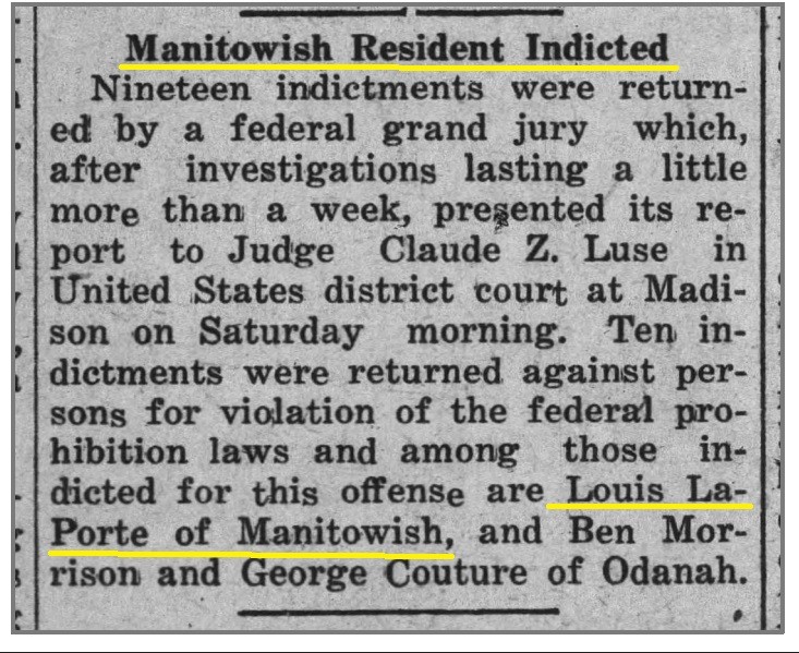
Two mystery features along the Camp Mercer Interpretive Trail were discovered in 2020, using LiDar imaging. These features are marked on the Camp Mercer Interpretive Trail map as 23 and 26. No interpretive signs have been created because of the ongoing scholarly debate between project historians and archaeologists. Several logging experts have reviewed these features and have no examples of comparable sites. The story that unfolds centers around Louie LaPorte, living between each of these features at the old LaPorte logging camp. LaPorte was a noted moonshiner who was indicted by a grand jury in 1924 for prohibition violations. Like many Northwoods moonshiners, LaPorte shrugged-off law enforcement trouble as an expected expense that comes with business.
It is illegal to dig, disturb or move cultural artifacts on public land without a permit from the State Archaeologist. Features 23 and 26 and other cultural sites like the logging camps are also protected because they are recorded on the Wisconsin Archaeological Site Inventory. Visitors are welcome to observe, explore, take photos and share stories around the features 23 and 26.
The logging camps are on public land and can be accessed by river or by the bike trail and the Manitowish River Access Road. Following the markers on the Camp Mercer Trail maps is the most efficient way to get to these sites.
Images
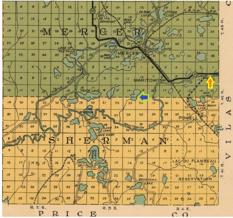
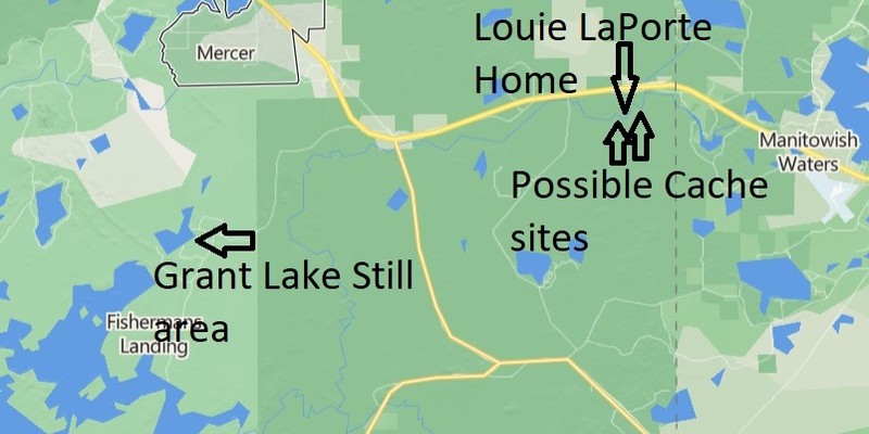
Location of County G, LaPorte still and probable caches
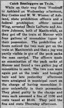
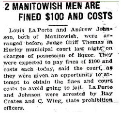
Detailed description of Louis LaPorte's arrest for bootlegging
1924 grand jury Indictment for Moonshineing
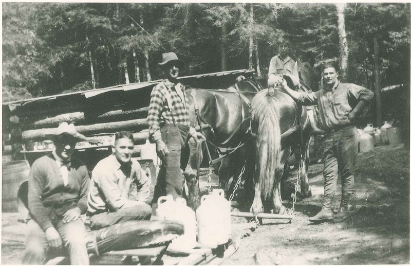
Grant Lake still, Louie LaPorte (standing in front) Emil Wanatka (seated with no hat)
Map illustrating the the site of the LaPorte still, Louie Laporte's home and probable caches
1922
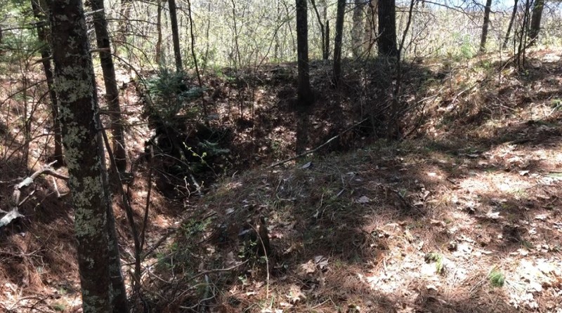
Feature 23
Backstory and Context
Text-to-speech Audio
The discovery of features marked on the Camp Mercer Interpretive Trail map as 23 and 26 has sparked a good scholarly debate. The features do not fit logging era or CCC traditions. Some have suggested they were ice houses, but Camp Mercer located its ice house well away from these features, according to a 1934 map. With the knowledge that Louie LaPorte lived in the old LaPorte logging camp in close proximity to each feature, along with LaPorte's role as both a moonshiner and a bootlegger, serious consideration of moonshine logistics became a plausible explanation for the mysterious features.
An onsite hike with an historian experienced in military logistics produced several helpful insights. The story of LaPorte's moonshine operation begins at Grant Lake at the still or "production facility" hidden deep in the woods. LaPorte could then move his moonshine either by road or the Manitowish River to the larger "wholesale" cache (feature 26), also hidden far from roads. The moonshiner could then move a smaller amount of moonshine a short distance down river to the smaller cache or "retail" site (feature 23), which happens to be next to an old two-track road just 1/4 of a mile from where Highways County G and State 51 merge. From feature 23, vehicles could be loaded in a matter of minutes and enjoyed many escape routes when leaving the cache.
The Town of Manitowish is between the Grant Lake still and the likely moonshine cache sites along the Camp Mercer Interpretive Trail. In historian Robert Gough's book, "Farming the Cutover, A Social History of Northern Wisconsin, 1900-1940," he suggests that moonshine activities were rampant along the railroads, too. Gough shared that during prohibition, the Chicago Northwestern train that crossed the Northwoods was referred to as the, "Whiskey Northern." Logistically, the rail stop in Manitowish was easy access for LaPorte and his moonshining contemporaries. Explore the news clippings above and discover that LaPorte and Andrew Johnson were arrested on the train between Manitowish and Mercer.
More research and debate needs to be conducted to confirm that these features are truly moonshine caches. Lacking other plausible explanations for features 23 and 26, the moonshine cache explanation seems to be probable.
Cite This Entry
Bokern, Jim and Frank DiLeonardi. "Probable Moonshine Cache Sites." Clio: Your Guide to History. February 2, 2023. Accessed August 7, 2025. https://theclio.com/entry/160511
Sources
"Catch Bootleggers on Tran." Iron County Miner (Hurley) February 3rd, 1922
Ironwood Daily Globe . Two Manitowish Men Are Fined $100 And Costs, Manitowish Waters Historical Society. February 3rd, 1922. Accessed December 10th, 2022.
Gough, Robert . Farming the Cutover A Social History of Northern Wisconsin 1900-1940. Lawrence , Kansas . University of Kansas Press, 1997.
Montreal Miner . Manitowish Residnet Indicted, Manitowish Waters Historical Society . March 14th, 1924. Accessed December 9th, 2022. https://mwhistory.pastperfectonline.com/photo/845F03B5-ECD0-49BB-BBD5-202185142437#gallery-4.
https://mwhistory.pastperfectonline.com/Photo/845F03B5-ECD0-49BB-BBD5-202185142437#gallery-3.
Standard Map Company . Map of Iron County, Wisconsin, Wisconsin Historical Society . 1932. Accessed December 9th, 2022. https://content.wisconsinhistory.org/digital/collection/maps/id/1918/rec/3.
Standard Map Company . Map of Iron County, Wisconsin, Wisconsin Historical Society . 1932. Accessed December 9th, 2022. https://content.wisconsinhistory.org/digital/collection/maps/id/1918/rec/3.
"Catch Bootleggers on Tran." Iron County Miner (Hurley) February 3rd, 1922.
Montreal Miner. Manitowish Resident Indicted, Manitowish Waters Historical Society . March 14th, 1924. Accessed December 9th, 2022. https://mwhistory.pastperfectonline.com/photo/845F03B5-ECD0-49BB-BBD5-202185142437#gallery-4.
Manitowish Waters Historical Society
Manitowish Waters Historical Society
Manitowish Waters Historical Society