Washington's Land
Introduction
Text-to-speech Audio
Images
WV Historical Marker
.jpg)
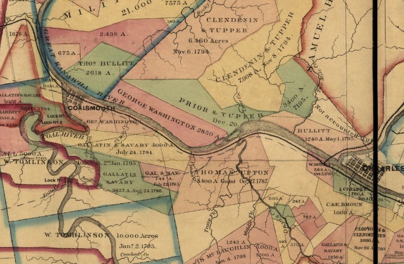
Section of title maps showing Washington's holdings near the Coal River
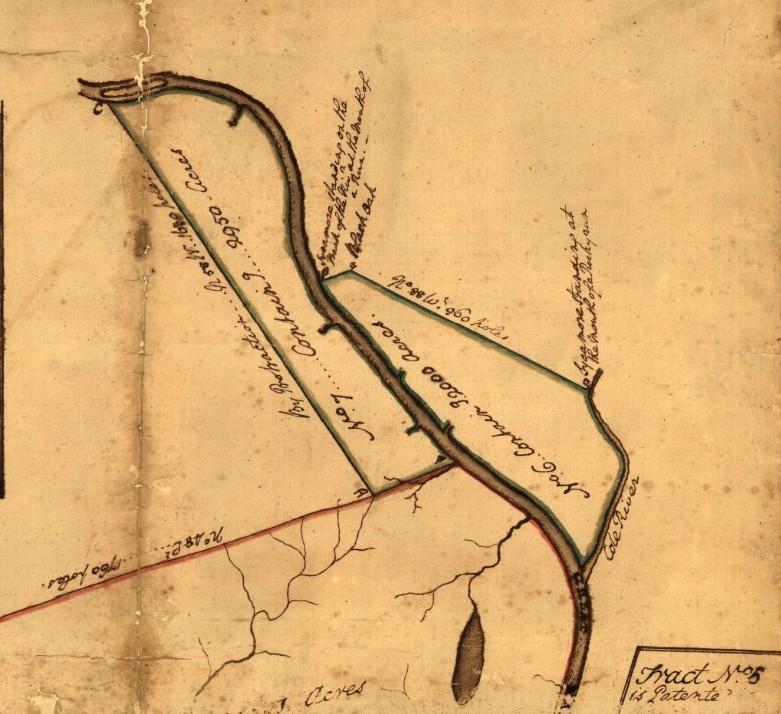
Section of survey map showing land tracts of Washington and others along the Kanawha
Backstory and Context
Text-to-speech Audio
George Washington claimed land in present St. Albans and across the river at Dunbar under the Royal Proclamation of 1763 which allowed veterans of the French and Indian War to claim unappropriated lands in the Ohio Valley region. By this point Washington had already claimed thousands of acres of land in (West) Virginia under bounties from a previous 1754 proclamation, but he looked to acquire additional lands by way of the 1763 Proclamation. He commissioned a survey in 1774 of acreage on the north side of the Kanawha River, however his claim was stalled due to the breakdown of relations between the colonies and Britain. The Virginia General Assembly re-validated the 1754 and 1763 proclamations in 1779 and in 1784 Governor Benjamin Harrison issued Washington’s grant for 2,950 acres at the location of present-day Dunbar. In the same year, Governor Harrison also granted Washington a warrant for 2,000 acres near the Coal River, the current site of St. Albans, WV. The St. Albans/Coal River land acquisition was a result of Washington purchasing the land warrant of another veteran. Washington still held these two tracts of land at his death and they were listed in his will as part of his “Great Kanawha” lands.
Washington's (West) Virginia lands:
As a young man George Washington explored into western Virginia and the Ohio Valley many times. In the Colonial period, Washington worked as a surveyor between 1749 and 1752 and traveled through the region during the French & Indian War. From these early experiences, he realized the importance of these western lands and continually invested in them for the rest of his life. Over the course of his life Washington owned 60,000 acres of western land, mostly in the area that would become West Virginia.
From an early age George Washington set out to increase his own fortunes, with the help of connections from family and wealthy friends. Washington’s father, Augustine Washington, died in 1743 when Washington was only 11. Augustine Washington’s oldest two sons, George Washington’s half-brothers Lawrence and Augustine Jr., inherited two of the three family tracts. George Washington, the eldest son of Augustine Washington’s second marriage to Mary Ball, inherited the third plot, which was the land at Ferry Farm where his mother and siblings lived. Washington ultimately owned around 600 acres at Ferry Farm, but because he inherited it as a minor it was managed by his mother until he reached the age of 21. Due to the poor prospects of the Ferry Farm land, George Washington decided to increase his fortunes through education and other pursuits, as well as through the connections and assistance of Lawrence Washington who served as a surrogate father-figure for the young boy. This is what prompted George Washington to study surveying and seek early employment in that field as a teenager, a decision that tied him to western lands for the rest of his life.
Washington learned the basic skills of surveying in school as a young man and practiced on the grounds of Mount Vernon, owned by his half-brother Lawrence Washington. The time that George Washington spent at Mount Vernon (which was the land that Lawrence Washington inherited from their father) proved crucial for George Washington’s future. Through his brother, Washington developed connections with the Fairfax family, neighbors of Mount Vernon living at the Belvoir estate a few miles away. Lawrence Washington married Anne Fairfax in 1743 and George Washington was often a guest at Belvoir. There he became acquainted with Colonel William Fairfax, owner of Belvoir, and the Colonel’s cousin Lord Thomas Fairfax. In the 1640s King Charles II had deeded millions of acres of Virginia land to loyal followers, including the Fairfax family, and by the 1740s the family land was all held by Lord Fairfax. Fairfax proved an important mentor in George Washington’s life and gave the young man his first start as a surveyor.
In 1748 George Washington accompanied George William Fairfax (Colonel William Fairfax’s son) and James Glen, surveyor of Prince William County, to survey Lord Fairfax’s western land holdings. The following year, at age 17, Washington gained an appointment as county surveyor in Culpeper County; he only served in that position for about a year, but he continued to survey in the area of Fairfax’s landholdings for two more years. It was through his connections to Lord Fairfax that Washington was able to acquire his first western land. At age 18 he purchased 453 acres of land from Lord Fairfax along Bullskin Creek (or Bullskin Run). He quickly received a grant for 93 additional acres and then bought 456 acres from James McCraken. After 1753 Washington set up a tobacco operation on part of these lands and leased other portions of land to tenant farmers for additional income. He visited the plantation a few times while still in the Virginia military, and was able to oversee the property more closely after 1759 when he settled at Mount Vernon after marrying Martha Custis. Ultimately, he would own almost 2,500 acres here. Additionally, he would visit brothers Samuel and Charles who both held estates in modern-day Jefferson County. Their estates were part of the land that Washington had surveyed for Lord Fairfax and George Washington convinced his brother Lawrence to purchase it; at Lawrence Washington’s death he gifted the land to the two younger brothers through his will.
Washington also held two lots by the warm springs at Bath, VA (now Berkeley Springs, WV). Washington learned about the “warm springs” when he was surveying the area around 1750 and continued to visit the springs throughout his life. He visited with his family several times in the 1760s after his marriage to Martha Custis. Besides the enjoyment of the springs for himself, the waters were one of several remedies that George and Martha Washington tried to cure Martha Parke Custis, Martha Washington's youngest daughter, who suffered from seizures (she would die from this ailment in 1773). The town of Bath (now Berkeley Springs) was established in 1776 and Washington bought two lots here. He hired James Rumsey to build a summer home and he still held the lots at his death in 1799.
Washington acquired more (West) Virginia land due to his service for the British in the French & Indian War. Governor of Virginia, Robert Dinwiddie, also took notice of young George Washington and made him an adjutant in the Virginia militia in 1753. Dinwiddie sent 20-year-old Washington into the Ohio Valley to warn the French to leave disputed lands that both Britain and France claimed. Washington passed through the region at least two more times during the French & Indian War, in 1754 in the expedition that resulted in Fort Necessity and in 1755 with Braddock’s Expedition. These military campaigns provided the groundwork for Washington’s military career, but also broadened his claim to western lands. To recruit men to serve in the army, in 1754 Governor Dinwiddie promised bounty lands in western Virginia as rewards and he set aside 200,000 acres for that purpose. Privates in the militia could earn 400 acres and the parcels increase with rank. The Royal Proclamation of 1763 also promised land to veterans of the French & Indian War; however, the 1763 Proclamation restricted British settlement into areas beyond the Appalachian Mountains so the bounties could not be immediately honored. In 1768, the British renegotiated the boundary line of Native lands with the Treaty of Fort Stanwix which opened up land to the Ohio River for white settlement.
Washington was a strong advocate for the lands in western Virginia to be opened for veterans and in 1769 the Virginia government approved a survey of land for these veteran bounties. Once they had permission to survey the promised 200,000 acres Washington and other officers explored the region between the Ohio River and the Little and Great Kanawha Rivers. Washington authorized Captain William Crawford, surveyor of August Co., to start surveying plots for veterans in 1771. Washington’s bounty allotment (from several different bounties claims) was around 15,000 acres but he also bought/assumed bounty lands from other veterans to increase his landholdings. By 1774 Washington claimed four tracts (23,216 acres) in the Kanawha Valley along the Ohio and Great Kanawha Rivers. Washington acquired additional lands on the Little Kanawha, the Great Kanawha, and the Little Miami Rivers between 1774 and 1790.
George Washington owned at least 30,000 acres in what became West Virginia. He took several trips to his western land holdings in his adult life, such as in 1784 where he checked on his land and explored the possibility of expanding the connection between the east and the west. As more Americans settled in the Ohio Valley, Washington and other politicians wanted to increase travel and trade to connect settlers to the American market instead of the British and Spanish markets to the north and west. Washington promoted the extension of road networks into the region and helped establish the Potomac Company, whose goal was to develop transportation links between the Potomac, James, and Ohio Rivers.
Sources
“Allegheny Expedition.” Mount Vernon. Accessed September 9, 2020. https://www.mountvernon.org/library/digitalhistory/digital-encyclopedia/article/allegheny-expedition/.
“Archive: George Washington Materials on Berkeley Springs and Area.” Archives of Washington’s Writings on Berkeley Springs. Accessed September 9, 2020. https://www.berkeleysprings.com/GWarchives/index.html.
“Battle of the Monongahela.” Mount Vernon. Accessed September 9, 2020. https://www.mountvernon.org/library/digitalhistory/digital-encyclopedia/article/battle-of-the-monongahela/.
“Belvoir.” Mount Vernon. Accessed September 9, 2020. https://www.mountvernon.org/library/digitalhistory/digital-encyclopedia/article/belvoir/.
“Bullskin Lands.” Mount Vernon. Accessed September 9, 2020. https://www.mountvernon.org/library/digitalhistory/digital-encyclopedia/article/bullskin-lands/.
“Eight survey tracts along the Kanawha River, W.Va. showing land granted to George Washington and others.” Library of Congress. Accessed September 9, 2020. https://www.loc.gov/resource/g3892k.ct000363/?r=0.219,-0.101,0.883,0.561,180
“Enclosure: Schedule of Property, 9 July 1799.” National Archives—Washington Papers. Accessed September 9, 2020. https://founders.archives.gov/documents/Washington/06-04-02-0404-0002#GEWN-06-04-02-0404-0002-fn-0008.
“Ferry Farm.” Mount Vernon. Accessed September 9, 2020. https://www.mountvernon.org/library/digitalhistory/digital-encyclopedia/article/ferry-farm/.
“Fort Necessity.” Mount Vernon. Accessed September 9, 2020. https://www.mountvernon.org/library/digitalhistory/digital-encyclopedia/article/fort-necessity/.
“George Washington’s Last Will and Testament, July 9, 1799.” Mount Vernon. Accessed September 9, 2020. https://www.mountvernon.org/education/primary-sources-2/article/george-washingtons-last-will-and-testament-july-9-1799/.
Hofstra, Warren R. “George Washington.” The West Virginia Encyclopedia. Accessed September 9, 2020. https://www.wvencyclopedia.org/articles/900.
“The Kanawha Tracts.” Mount Vernon. Accessed September 9, 2020. https://www.mountvernon.org/library/digitalhistory/digital-encyclopedia/article/the-kanawha-tracts/.
“Lawrence Washington.” Mount Vernon. Accessed September 9, 2020. https://www.mountvernon.org/library/digitalhistory/digital-encyclopedia/article/lawrence-washington/.
“Lord Fairfax.” Mount Vernon. Accessed September 9, 2020. https://www.mountvernon.org/library/digitalhistory/digital-encyclopedia/article/lord-fairfax/
“Martha Parke Custis.” Mount Vernon. Accessed September 9, 2020. https://www.mountvernon.org/library/digitalhistory/digital-encyclopedia/article/martha-parke-custis/.
Maxwell, William B. “Washington’s Western Lands.” The West Virginia Encyclopedia. Accessed September 9, 2020. https://www.wvencyclopedia.org/articles/2344.
Maxwell, William B., Esq. West Virginia Historical Society. Vol XXIV, no. 1 (Spring 2010): 1-15. http://www.wvculture.org/history/wvhs/wvhs2401.pdf.
“Ohio River Valley.” Mount Vernon. Accessed September 9, 2020. https://www.mountvernon.org/library/digitalhistory/digital-encyclopedia/article/ohio-river-valley/.
“The Potomac Company.” Mount Vernon. Accessed September 9, 2020. https://www.mountvernon.org/library/digitalhistory/digital-encyclopedia/article/the-potomac-company/.
Rice, Otis K. “Bounty Lands.” The West Virginia Encyclopedia. Accessed September 9, 2020. https://www.wvencyclopedia.org/articles/628.
“Surveying.” Mount Vernon. Accessed September 9, 2020. https://www.mountvernon.org/library/digitalhistory/digital-encyclopedia/article/surveying/.
“Washington and the West.” Mount Vernon. Accessed September 9, 2020. https://www.mountvernon.org/library/digitalhistory/digital-encyclopedia/article/washington-and-the-west/.
“Washington as Public Land Surveyor.” Library of Congress. Accessed September 9, 2020. https://www.loc.gov/collections/george-washington-papers/articles-and-essays/george-washington-survey-and-mapmaker/washington-as-public-land-surveyor/.
“Washington’s Lots.” The Washington Heritage Trail in Morgan County. Accessed September 9, 2020. https://www.berkeleysprings.com/trail/gwtrail-7.html.
Further Reading:
Abernethy, Thomas Perkins. Western Lands and the American Revolution. New York: Appleton-Century-Crofts, 1937.
Achenbach, Joel. The Grand Idea: George Washington's Potomac and the Race to the West. New York: Simon and Schuster, 2002.
Chase, Philander D. George Washington and the Virginia Backcountry. Madison, Wisconsin: Madison House, 1998.
Cook, Roy Bird. Washington’s Western Lands. Strasburg, Virginia: 1930.
Ferling, John. The Ascent of George Washington: The Hidden Political Genius of an American Icon. New York: Bloomsbury Press, 2009.
Hughes, Sarah. Surveyors and Statesmen: Land Measuring in Colonial Virginia. Richmond: Virginia Surveyors Foundation and Virginia Association of Surveyors, 1979.
"General Washington's Lands." The Historical Magazine, and Notes and Queries Concerning the Antiquities, History, and Biography of America (1857-1875).
Knollenberg, Bernhard. George Washington, the Virginia Period, 1732-1775. Durham, NC: Duke University Press, 1964.
Prussing, Eugene E. The Estate of George Washington, Deceased. Boston: 1927.
Rice, Otis K. The Allegheny Frontier: West Virginia Beginnings, 1730-1830. Lexington: University Press of Kentucky, 1970.
"Washington's Land." Waymarking.com. Accessed September 10, 2020. https://www.waymarking.com/waymarks/WMH64V_Washingtons_Land.
Swann, John S, and G.W. & C.B. Colton & Co. Title map of the coal field of the great Kanawha Valley. New York: G.W. & C.B. Colton, 1867. Map. https://www.loc.gov/item/00561201/.
Washington, George, Samuel Lewis, and William Crawford. Eight survey tracts along the Kanawha River, W.Va. showing land granted to George Washington and others. [?, 1774] Map. https://www.loc.gov/item/75693268/.