Carter Park, 602 South River Street
Introduction
Text-to-speech Audio
Images
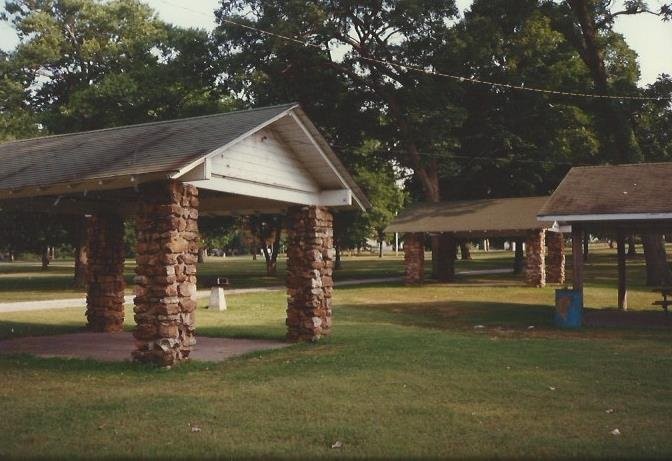
Native rock shelters in Carter Park that were used as early as the late 1910s for auto campers picnicking in the park.
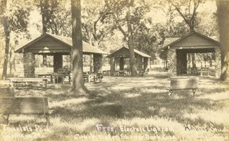
Historic postcard of Tourist Park in the 1920s.
Digitization on CLIO is part of Powers Museum's "Digital Carthage" project in honor of Carthage's 175th Anniversary Celebration (March 28, 2017 through March 27, 2018).
Funding for the Walking in the Wards tour was made possible by a grant from the Missouri Humanities Council and the National Endowment for the Humanities, Spring 2017.

Backstory and Context
Text-to-speech Audio
The northern entrance off River street was created when the stone entrance gate to Cassil Place on West Central Avenue was moved to this location (see Clio entry for Cassil Place on West Central Avenue). For many years the corner at Chestnut and River Streets also had Carthage limestone pillars that formed an arched gateway and second entrance into the park but in 2016, those were moved further east on Chestnut to keep them from being repeatedly damaged by truck traffic. Next to these pillars at the River and Chestnut location was a marker with the text "July 5, 1861" to denote the Battle of Carthage action by both sides in this vicinity. That marker still stands on its original site.
The park was home to leisure activities and sports events in the late 19th century through the first decade of the 20th century at which point it was developed into Carthage's Tourist Park for auto travelers using the early named highways such as the Ozark Trails and the Jefferson Highway. Facilities were added for tent and car camping and some of the rock shelters from this period still exist although the rock cabins do not. The Tourist Park was noted in AP news wire stories in the 1930s as one of best tourist parks along U. S. Highway 66. (U.S. 66 originally came into Carthage from the east via River Street and turned west at Central Avenue, so the park was only a couple blocks away.)
In the 1930s the park also was used for New Deal recreational programs and would also become home to Boy Scout and Girl Scout activities in later decades.Today the park is still used for picnicking and sports events.
Late 2018 Update: Southern portion of the rock entrance gates seen in the Google image have been damaged.
Sources
Hansford, Michele. Images of America: Carthage Missouri. Charleston SC: Arcadia Publishing, 2000.
Powers Museum Vertical Files: Dr. J A Carter, Carter Park
Contemporary image of Carter Park by Michele Hansford.
Tourist Park postcard former Powers Museum exhibit image.