UCV Civil War Military Operations Marker #15: Cavalry fight between Mosby's Rangers and Blazer's Independent Scouts, November 18, 1864
Introduction
Text-to-speech Audio
Images
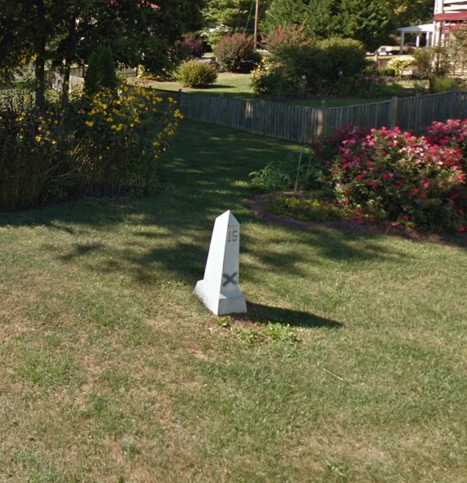
Obelisk #15
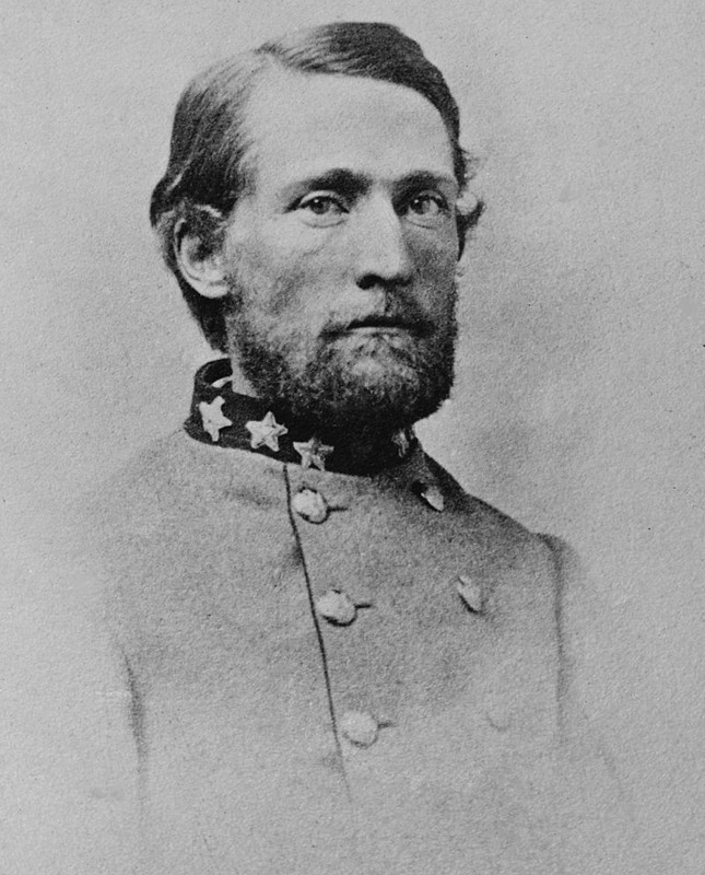
Colonel John S. Mosby
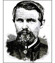
Captain Richard Blazer
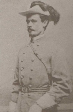
Captain Adolphus "Dolly" Richards
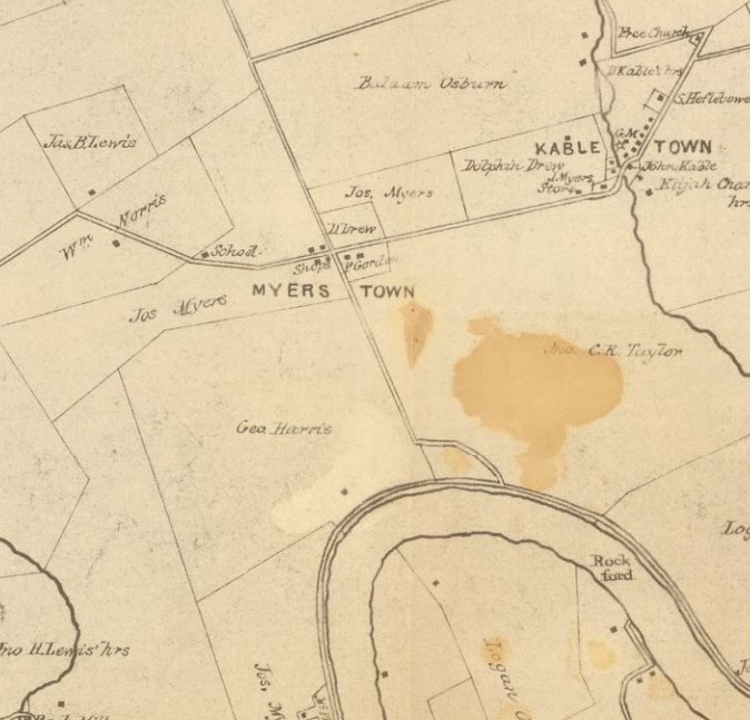
Section of 1862 Map of Jefferson County, showing Myerstown and the property of George Harris
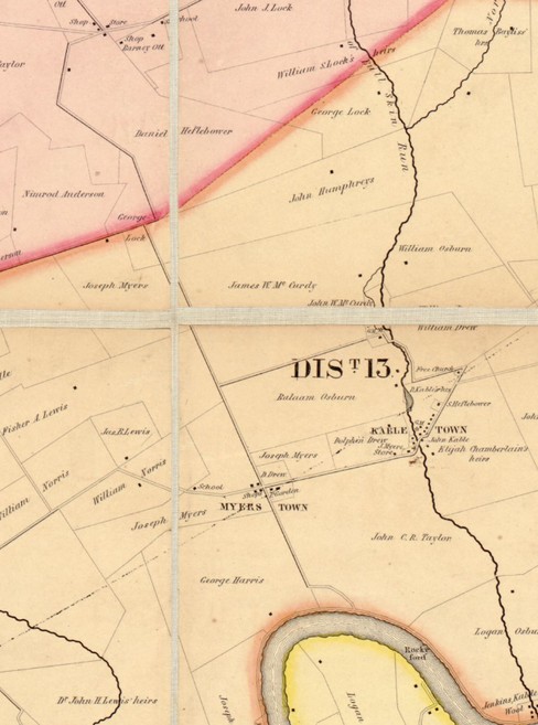
Section of 1852 Map showing location of Harris property where Richards posted his men and the Heflebower property near where Blazer was captured.
Union reports in the aftermath of Blazer's defeat, page 1
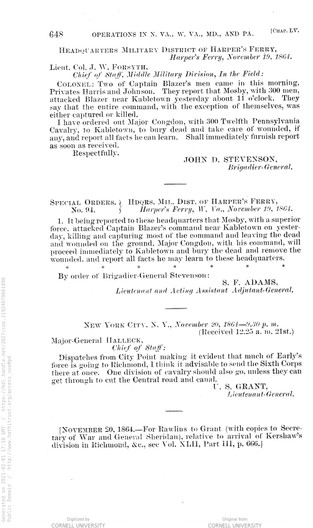
Union reports in the aftermath of Blazer's defeat, page 2
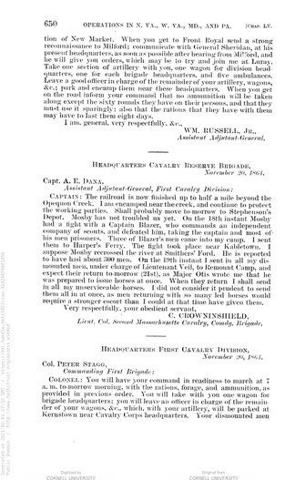
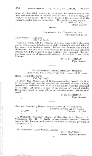
Union reports in the aftermath of Blazer's defeat, page 3

Backstory and Context
Text-to-speech Audio
During the 1864 Shenandoah Valley Campaign between Generals Philip Sheridan and Jubal Early, Confederate Lieutenant Colonel John S. Mosby and his raiders operated to harass Sheridan’s operations in the region. Mosby’s partisan-style attacks and ability to inflict damage and disappear earned him the name the “Gray Ghost” and his raiders were such a nuisance to Sheridan that he ordered a force of men picked and tasked with the goal of neutralizing Mosby in the Valley. This force was 100 picked men called the Independent Scouts led by Captain Richard Blazer. Blazer and Mosby operated against each other starting in September, but Mosby’s prime objective remained Sheridan’s Army.
The major fighting of the 1864 Shenandoah Valley Campaign between Generals Sheridan and Early had largely ended by October, and many of those forces returned east to support the Overland Campaign around Petersburg, VA. Once Sheridan’s force went into winter encampment and stopped major operations, Mosby continued to operate in the Valley and turned his attention to Blazer’s Scouts. In early November 1864, the cavalry of Mosby and Blazer circled and tracked each other with no real fighting. Mosby became ill and could not travel with his men for a period, and he divided his raiders into two groups of around 80 men each under Lieutenants William Chapman and Adolphus Richards. On November 17, 1864 the two forces gained intelligence of each other’s positions and in the morning of November 18 Richards took a position along a route that Blazer’s men were expected to travel.
Richards concealed his raiders in a section of woods near the farm of George Harris, close to Meyerstown. He hoped to be able to attack the Union Scouts at closer range so that the Federals could not use their long-range rifles to an advantage. Blazer’s men approached their position as anticipated, but Richards’ ambush was foiled by one of his own raiders who was drunk and stepped out into the road while firing his pistol, thus giving away their position. At this, the Union Scouts stopped and took cover behind a stone wall rather than riding into Richards’ ambush. Needing to still draw the Union force forward somehow, Richards quickly devised a new plan. He had one of his men, Harry Hatcher, lead Company A in a fake retreat to lure Blaze’s men forward, which worked. As the Independent Scouts charged forward, they encountered the rest of Richards’ force still lying in ambush. The Confederate attack completely scattered the Union force which was almost entirely killed, wounded, or captured. Captain Blazer and the survivors of the ambush rode out of the woods and headed onto the Myerstown Road towards Rippon where most were captured by Richards’ pursuers. Confederate Syd Ferguson pursued Blazer and since his pistols were empty used the butt of his gun to strike the Captain on his head, forcing Blazer to fall off his horse near the home of Daniel Heflebower. Ferguson came back after the fight was concluded to collect Captain Blazer as a prisoner.
Captain Blazer’s Independent Scouts was completely destroyed by this engagement. The Union lost 24 killed, 12 wounded, and 62 captured; only five of the Scouts escaped to report what happened. In contrast, Richards lost one man killed and seven wounded. According to an early historian of Jefferson County, Millard Kessler, this was one of the most destructive cavalry engagements of the war in proportion to the number of men engaged (about 80 men on each side).
About the Monuments:
This series of monuments and accompanying tour pamphlet were part of an initiative from the Jefferson County Camp, United Confederate Veterans to commemorate the 50th anniversary of the Civil War. In 1910 Col. R. Preston Chew and the Jefferson County UCV raised the funds to place 25 concrete obelisks in Jefferson County to mark locations of engagement or other significant events. The following year the Camp published a pamphlet to accompany the obelisks and give more information about each location. This was Military Operations in Jefferson County, Virginia (Now West Virginia), 1861-1865 published in 1911. The pamphlet has been reprinted several times by the Henry Kyd Douglas Camp, No. 199 of the Sons of Confederate Veterans. Because the monuments and accompanying pamphlet were done by Confederate veterans it is likely that the locations and descriptions are biased towards or favor the Confederate view and experience of the war.
Original Text from the 1911 Pamphlet:
"Marker Number Fifteen
Slaughter and Capture of Blazer’s Men at Myerstown
Richards started on November 17, 1864, with 100 Rangers to look for Blazer. Most of his men were especially anxious to set eyes on the Northerner. They were not picked men, however, but just plain, ordinary, every-day guerillas.
When Richards reached Castleman’s Ferry he heard that Blazer was on a raid looking for Mosby, having fully made up this mind to finish the contract about which Sheridan had wired Augur nearly three months before. We located him in camp near Kabletown, in Jefferson county, West Virginia. Richards preferring a daylight fight, camped near him. In the morning our men were so anxious for a settlement with Blazer’s command that they did not wait for breakfast, but at sunrise galloped into Kabletown, only to find that Blazer had left but a few moments before, “looking for them.”
It didn’t take very long to find the blue column, which presently appeared across a field. Richards turned his men from the road to draw Blazer on, but Blazer was busy taking down a fence and dismounting his cavalry, so as to use his Spencers at long range. Richards instantly divided his command and started with half his men, as though retreating. Blazer bit and ordered a charge. When his men got clear of the woods and into the open, where there was no furniture in the way of our little game of tag, Richards turned on him and our two divisions charged simultaneously.
Blazer’s men used their Spencers until we got close up to them, when they dropped their rifles and drew revolvers. Richards’ attack was very much in the nature of a dynamite explosion at close range, and while there is no doubt that Blazer counted on a fight and really wanted one, he had made no preparations for a massacre. His “picked 100 men” broke before our onslaught, defying all their commanders efforts to rally them, and the flight because a panic and a rout.
Captain Blazer was overtaken by “Syd” Furguson, who rode one of the best mares in our command. Blazer was knocked from his horse with the butt of a pistol and picked up blind and bleeding from the ground. He came to the scratch cheerfully even in defeat, and took his medicine like a man. His loss was more than 20 men killed, many more wounded, most of them mortally, and about 30 of his command were taken prisoners. General Stevenson dispatched on November 19, “two of Captain Blazer’s men came in this morning—Privates Harris and Johnson. They report that Mosby attacked Blazer near Kabletown yesterday about 11 o’clock. They say the entire command, with the exception of themselves, was either captured or killed.”"
Sources
Bushong, Millard Kessler. A History of Jefferson County, West Virginia. Charles Town, WV: Jefferson Publishing Company, 1941.
Engle, Stephen Douglas. Thunder in the Hills: Military Operations in Jefferson County, West Virginia, During the American Civil War. Charleston, WV: Mountain State Press, 1989.
Military Operations in Jefferson County Virginia (and West Va.) 1861-1865. Published by Authority of Jefferson County Camp U.C.V. Farmers Advocate Print, 1911. Accessed January 20, 2021. https://babel.hathitrust.org/cgi/pt?id=uc2.ark:/13960/t4vh5gp6c&view=1up&seq=5.
Google Maps. Accessed February 1, 2021.
"John S. Mosby." Wikipedia. Accessed February 1, 2021. https://en.wikipedia.org/wiki/John_S._Mosby.
"Blazer's Scouts." West Virginia in the Civil War. Accessed February 1, 2021. https://wvcivilwar.com/blazers-scouts/.
"Identifying more unknowns: Blazer's Scouts killed in the Kabletown fight against Mosby's Rangers." Cenantua's Blog. Accessed February 1, 2021. https://cenantua.wordpress.com/2011/09/04/identifying-more-unknowns-mosby-vs-blazers-scouts/.
United States Topographical Bureau, and Samuel Howell Brown. Map of Jefferson County, Va. photographed for the Bureau of Topographical Engineers Oct. [S.l.: s.n., ?, 1862] Map. https://www.loc.gov/item/lva0000085/. Accessed February 2, 2021. https://www.loc.gov/resource/glva01.lva00085/?r=0.052,0.494,0.378,0.151,0.
"Map of Jefferson County Virginia By S. Howell Brown from actual survey with the farm limits, 1852." WV GeoExplorer. Accessed February 2, 2021. http://www.wvgeohistory.org:8080/Portals/0/zoomify/URLDrivenPage2.htm?zImagePath=/Portals/0/zoomify/s_howell_brown_1852&zSkinPath=Assets/Skins/Default.
The War of the Rebellion: a Compilation of the Official Records of the Union and Confederate Armies. Series.1:vol.43:pt.2:Correspondence. p. 648. Accessed February 1, 2021. https://babel.hathitrust.org/cgi/pt?id=coo.31924079601096&view=1up&seq=3.
The War of the Rebellion: a Compilation of the Official Records of the Union and Confederate Armies. Series.1:vol.43:pt.2:Correspondence. p. 650. Accessed February 1, 2021. https://babel.hathitrust.org/cgi/pt?id=coo.31924079601096&view=1up&seq=3.
The War of the Rebellion: a Compilation of the Official Records of the Union and Confederate Armies. Series.1:vol.43:pt.2:Correspondence. p. 654. Accessed February 1, 2021. https://babel.hathitrust.org/cgi/pt?id=coo.31924079601096&view=1up&seq=3.