Harpers Ferry Historic Blocks C, D, E, F, & G
Introduction
Text-to-speech Audio
This stretch of Shenandoah was once populated with residences, commercial buildings, and other structures related to the United States Armory. Prior to the Civil War this was a bustling street due to the industry and transportation routes present in Harpers Ferry. Almost nothing remains from this section of town due to floods prior to 1936 that destroyed most of the structures.
Images
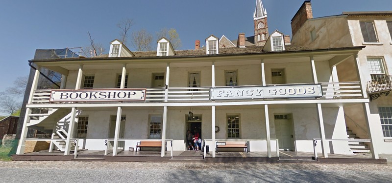
"Armory Dwelling No. 3 on U.S. Lot 1--Now a NPS visitor center.
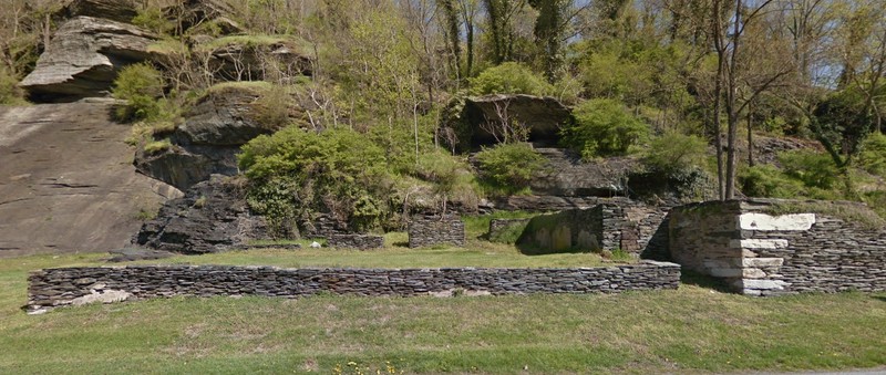
Foundations of the Presbyterian Church on Shenandoah Street
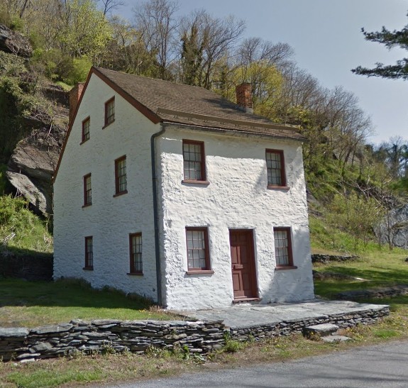
Armory Dwelling House No. 5 is one of the only structures remaining on Shenandoah Street
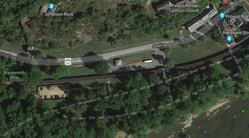
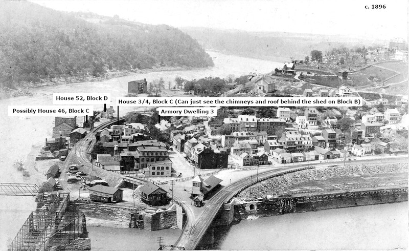
Aerial of what used to be blocks C through G on Shenandoah Street
Blocks C through G in 1859 (Harpers Ferry Historical Base Map, 1859, Part of the Master Plan, Harpers Ferry National Historical Park)
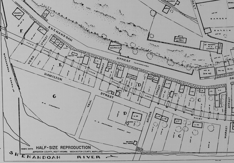
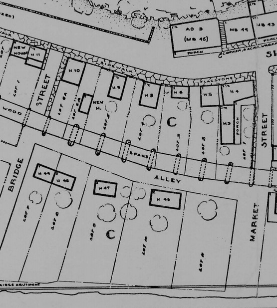
Block C, Shenandoah Street
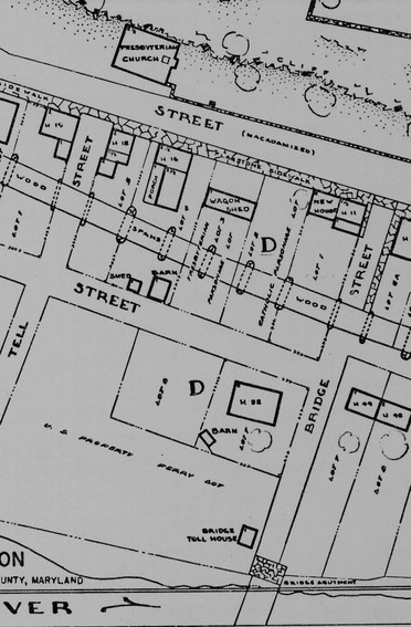
Block D, Shenandoah Street
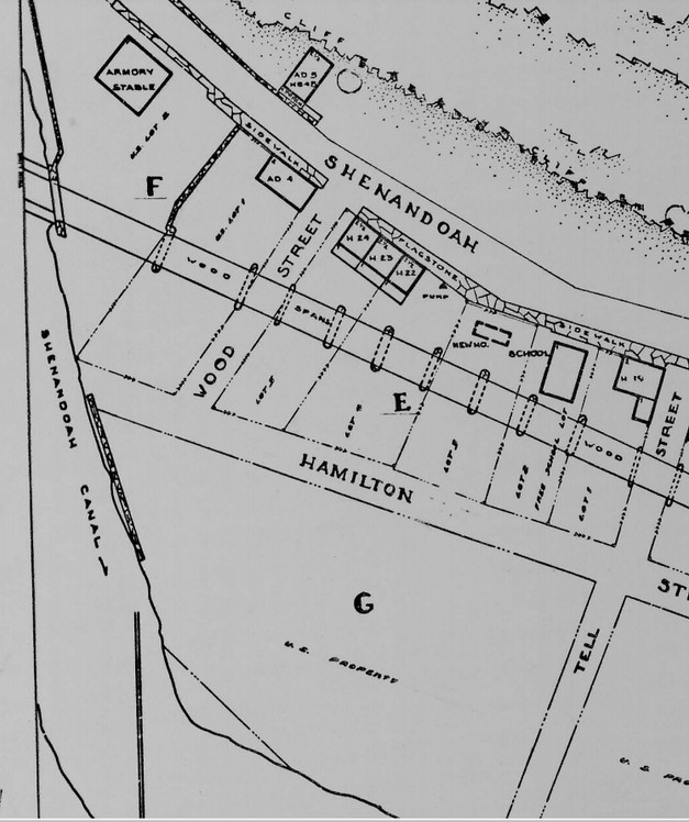
Blocks E, F, G, Shenandoah Street
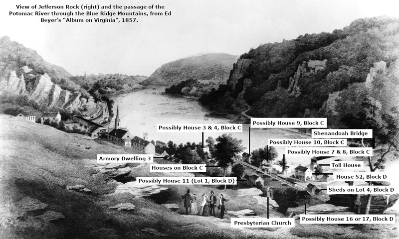
"View of Jefferson Rock (right) and the passage of the Potomac River through the Blue Ridge Mountains, from Ed Beyer’s “Album on Virginia”, 1857."
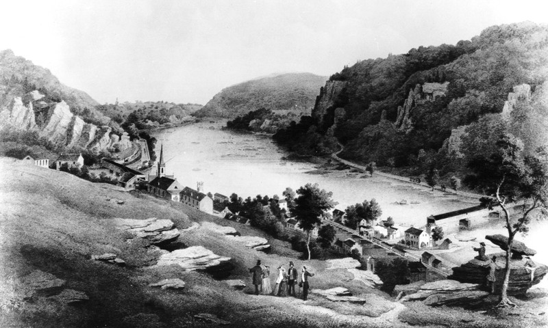
Labeled "View of Jefferson Rock (right) and the passage of the Potomac River through the Blue Ridge Mountains, from Ed Beyer’s “Album on Virginia”, 1857."
"St. Peter's Church & Rectory, Lower Town, Harpers Ferry, circa 1895."
Labeled "St. Peter's Church & Rectory, Lower Town, Harpers Ferry, circa 1895."
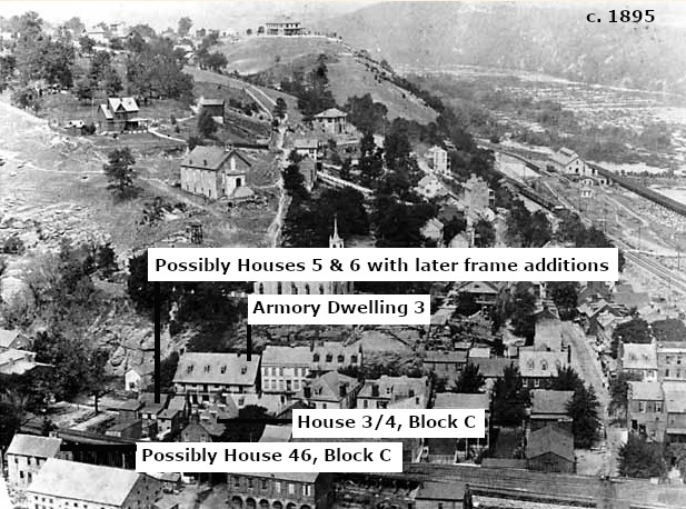
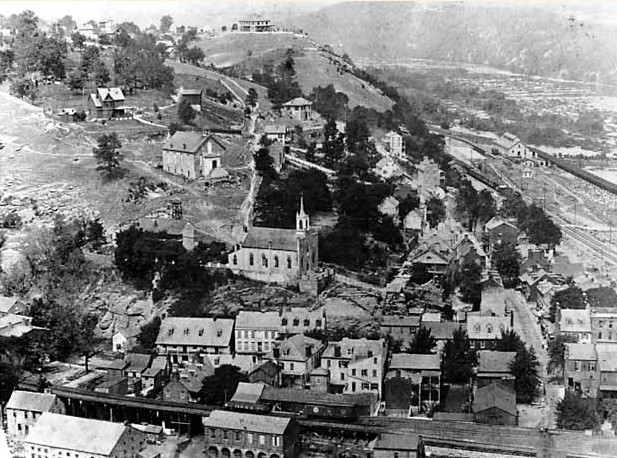
View of Harpers Ferry in 1896
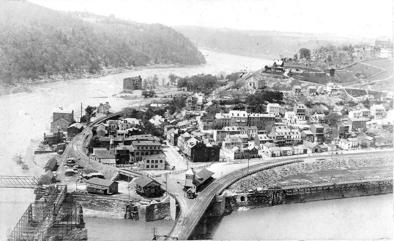
Labeled View of Harpers Ferry in 1896
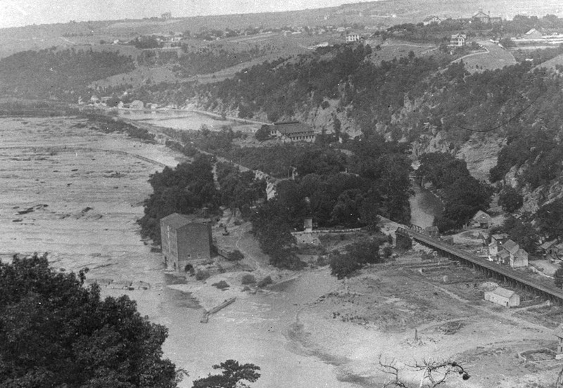
View of Virginius Island from Loudon Heights, c. 1889. The cotton mill on Virginius Island is at the center and a few of the structures along Shenandoah Street are visible in the lower right.
Backstory and Context
Text-to-speech Audio
Descriptions of historic structures from the 1980 National Register of Historic Places Nomination:
U.S. Lot No. 1, Shenandoah Street
Armory Dwelling No. 3—“It was built by John G. Wilson in 1825-26 as a store and enlarged by Mrs. Ann C. Stephenson as an inn or hotel in 1833-34. The 2-1/2-story stone gable-roofed structure measures 66’3” by 35’9”. A two-story frame porch runs the length of the front evaluation. During the 1840s and 50s two small shops were located on the first floor and the upper floors were also divided to house two families. In 1859 saddlemaker, tailor, or grocery shops probably occupied the ground floor. During the Civil War the building was a Union Army warehouse, being listed as Ordnance Department Warehouse No. 3 in July 1865 and then needing repair. The U.S. Government sold the property in 1869. Again in Government ownership, the building has been restored to its 1859 appearance and is now used as a National Park Service visitor center.
Block C, Shenandoah Street—these buildings were all destroyed in flooding but some remains are present under the parking lot the National Park Service installed in 1957-58.
Lot 1: Houses No. 3 and 4—“Lot 1, on the corner of Shenandoah and Market streets, contained Houses No. 3 and 4, constructed by William Graham about 1818-20. House No. 4 was a 2-1/2-story stone building with a slate roof designed for use as a store and dwelling. It fronted approximately 43’ on Shenandoah Street and went back about 33’ along Market Street. The white-painted building contained a dry goods and grocery store in 1850. House No. 3, once known as the Globe Inn, was a 2-1/2-story brick structure with slate roof located to the rear of House No. 4. A two-story covered frame porch extended the length of the 50’ Market Street façade. The building was about 20’ deep, not including the 9’-wide porch. In 1859 the lot and both houses were owned by the heirs of Edward Lucas, Jr., the late Paymaster of the Armory.”
Lot 2: House No. 5—“erected by the United States between 1818 and 1834. The two-story brick structure with wood shingle roof fronted approximately 25’ on Shenandoah Street and was about 28’ deep. It was owned and occupied by Ralph Cleveland, an armorer, in 1859.”
Lot 3: House No. 6—“erected by the United States between 1811 and 1834. The two-story brick structure with wood shingle roof fronted approximately 24’ on Shenandoah Street and was about 17’ deep. The house was occupied by the Henry Stripes family, armorers, in 1859.”
Lot No. 4: House No. 8—“erected by the United States between 1811 and 1834. The 1-1/2-story brick building with wood shingle roof fronted approximately 24’ on Shenandoah Street and was about 32’ in depth. In 1859 it was owned by John B. Johnson, an armorer, and was apparently rented as a dwelling by Francis M. Pine, a clerk.”
Lot No. 5: House No. 9—“erected by the United States between 1811 and 1834. The 1-1/2-story brick dwelling with wood shingle roof fronted approximately 20’ on Shenandoah Street and was about 32’ deep. It was owned and occupied by the George P. Marquett family in 1859.”
Lot 6A: House No. 10—“erected by the United States between 1811 and 1834. The two-story stone dwelling with wood shingle roof fronted approximately 30’ on Shenandoah Street and was about 32’ in depth. In 1859 it was owned by Andrew J. Wright, an armorer, and was probably rented by Benjamin Hobbs, an armorer.”
Lot 6B—“the site of a two-story brick house built and occupied by Jesse Grimes (or Graham), and armorer, between 1857 and 1859. The house measured approximately 17’ by 24’.”
Lot 7: House No. 49—“erected by the United States between 1811 and 1834. The one-story brick dwelling adjoined the house on Lot No. 8; the two houses together measured approximately 54’ by 18’. In 1859 House No. 49 was the residence of Joseph Manuel, a Blacksmith, and Joseph Davis, Blacksmith’s apprentice.”
Lot 8: House No. 48—“erected by the United States between 1811 and 1834. The two-story brick dwelling was owned and occupied by Bernard McCabe, a coal breaker, in 1859.”
Lot 9: House No. 47—“erected by the United States between 1811 and 1834. The two-story stone dwelling measured approximately 28’ by 18’. In 1859 it was owned by the heirs of Francis McCabe and was apparently rented by Daniel Potterfield, a butcher, and Thomas Gallaher, a liquor dealer.”
Lot No. 10: House No. 46—“erected by the United States between 1811 and 1834. The two-story stone dwelling measuring 40’ by 22’ was owned and occupied by Samuel Trail, a carpenter, in 1859.”
Lot No. 11—“owned by the United States, was under contract of sale to the late Edward Lucas, Jr., in 1859 but not paid for. It was then vacant.”
Block D, Shenandoah Street—Floods destroyed the structures along this stretch until the flood of 1936 removed the final traces. Foundations of these structures exist under the NPS parking lot which was added in 1957-58.
Lot No. 1: House No. 11—“erected by the United States between 1811 and 1834. The brick dwelling had 1-1/2 stories and a wood shingle roof and measured 22’ by 18’. A second house was erected on the lot between 1852 and 1857 by Master Armorer Armistead M. Ball, who was residing in one of the houses in 1859.”
Lot No. 2—“was leased by the Catholic Church from the Government prior to the Civil War as the site for a parsonage. The lot was vacant in 1859. (Michael A. Costello, the priest, was then residing at the house of William J. Stephens on Wager Lot No. 5).”
Lot No. 3—“was leased by the Presbyterian Church from the Government prior to the Civil War as the site for a parsonage. The church then had a visiting pastor from Berryville, and no parsonage was erected. The lot was instead occupied by a frame carriage house with shake roof serving the church, which was directly across the street.”
Lot No. 4: House No. 16—“erected by the United States between 1811 and 1834. The brick dwelling had 2-1/2 stories and a slate roof and measured about 39’ by 19’. Between 1853 and 1859 Philip Hoffman, the resident, built a 2-1/2-story brick addition measuring approximately 29’ by 17’. Two small frame barns or sheds fronted on Hamilton Street at the rear of this lot.”
Lot No. 5: House No. 17—“erected by the United States between 1811 and 1834. The brick dwelling had 1-1/2 or two stories and a slate roof and fronted about 21’ on Shenandoah Street. It was approximately 42’ deep, including a 15’ by 15’ addition at the rear. In 1859 the house was owned by Joseph Mathews, an armorer, and was probably rented by Thomas B. Moore, a merchant.”
Lot No. 6—“owned in 1859 by the heirs of Edward Lucas, Jr., former Paymaster of the Armory, was then vacant.”
Lot No. 7: House No. 52—“erected by Philip Coons in 1825-26. The two-story stone dwelling measured 39’ by 28’. To the southwest was a small one-story barn or shed. In 1859 the house was the residence of Samuel L. Williams, an Armory watchman, and a portion was rented to James Pagate, a mill agent.”
Presbyterian Church Lot, Shenandoah Street
“This lot was owned by the United States prior to the Civil War and leased to the Presbyterian Church. The church building, with a one-story stone basement and one brick story above, was erected in 1843. It measured 36’ by 49’ and had a wooden cupola mounted on the roof. During the war the upper floor was used as a guard house and the basement as a stable by the Union Army. The badly damaged structure was repaired after the war, but today only the ruined first story remains.”
Block E, Shenandoah Street: residences were largely destroyed in the 1936 flood, foundations are in place.
Lot No. 1: House No. 19—“erected by the United States between 1811 and 1834. The house was a two-story brick dwelling with a wood shingle roof and measured approximately 30’ by 19’. William H. Martin, and Armory inspector, was its tenant in 1859.”
Lot No. 2: Free School for School District No. 24—“leased by the Government to the County School Board prior to the Civil War, was the site of a one-story brick school building of unknown dimensions—the Free School for School District No. 24. Erected in 1855, the school was demolished by Union soldiers during the war.”
Lot No. 3—“owned by Michael Doran, a merchant, prior to the Civil War. He may have constructed a new house on the lot between 1852 and 1861, but not definite evidence of it has been found.”
Lot No. 4: House No. 22—“erected by the United States between 1811 and 1834. The stone dwelling had 2-1/2 stories and a wood shingle roof. It fronted approximately 18’ on Shenandoah Street and was about 22’ deep. In 1859 it housed the Nunnamaker family, who were employed at the Armory. A town pump was then located on the lot.”
Lot No. 5: Houses No. 23 and 24—“erected by the United States between 1811 and 1834. Each of these 2-1/2-story brick and frame dwellings with wood shingle roofs fronted on Shenandoah Street about 21’ and was 22’ deep. In 1859 House No. 23 was rented to John Koonce, a polisher of gun barrels, and House No. 24 was the residence of William Snook, an inspector of gun barrels.”
U.S. Lot 1, Block F, Shenandoah Street
Armory Dwelling No. 4—“a two-story brick building with wood shingle roof approximately 38’ by 21’, was erected between 1811 and 1834. In 1859 it was probably rented by two families of Armory workmen. In July 1865 it was in bad condition and vacant. There are no visible remains.”
U.S. Lot 2, Shenandoah Street
Armory Dwelling House No. 5—“a 2-1/2-story stone house 18’ by 32-1/2’ in plan, was erected on this lot north of Shenandoah Street between 1821 and 1834. It was rented by the family of an armorer prior to the Civil War, at the close of which it was vacant and in fair condition. The exterior was restored to its 1859 appearance in 1968 and the original interior stairway has been reconstructed. It is presently used as a residence.”
Armory Stable—“designed by Maj. John Symington, was erected on Block F of this lot south of Shenandoah Street in 1847-48. It was a one-story brick building with cut stone water table and coping and a slate roof. The structure was similar in design to Building No. 1, the Engine and Guard House, in the Musket Factory yard. It contained stalls for at least six horses. In 1856 stone walls were erected on two sides of the stable to enlarge the grounds. In July 1865 the stable was in good condition and being used by the Union Army.”
Block G, Shenandoah Street—this was the Armory Lumber Yard until it was destroyed in a flood in 1852 after which the lot was vacant.
U.S. Ferry Lot, Shenandoah Street: Shenandoah Toll Bridge and Bridge Toll House.
Shenandoah Toll bridge—“The Shenandoah Toll Bridge crossed from the southern extremity of Bridge Street adjacent to the U.S. Ferry Lot. The United States owned the ferry rights across the Shenandoah from 1818 until after the Civil War. A rope ferry crossed the river from 1810 until 1844. In 1843-44 the Shenandoah Bridge Company constructed its toll bridge. In return for not exercising its ferry rights, the United States received free passage of all Armory personnel and property across the bridge. The bridge was composed of two stone abutments, two stone piers, and a wooden superstructure 375’ long. The piers were 28’ high, 30’ long, 10’ thick at the base and 6’ thick at the top. The arched superstructure had a double wagon track, each being 10’ wide and 12’ high in the clear. It was weatherboarded and covered with cypress shingles. The original superstructure was destroyed by a hurricane in June 1859 and rebuilt by September, but was not covered at the time of John Brown’s raid. Confederate troops burned the bridge on June 28, 1861. There are no evident remains.”
Shenandoah Bridge Toll House—“a small 1-1/2-story frame building erected by the Shanandoah Bridge Company in 1844, stood at the northern end of the bridge on the U.S. Ferry Lot. The lot, owned by the United States and leased to the company, was otherwise vacant.” Like the other structures along this stretch of Shenandoah Street, floods destroyed the toll house by 1936.
Sources
"National Register of Historic Places Inventory--Nomination Form: Harpers Ferry National Historical Park." Accessed August 5, 2021. http://www.wvculture.org/shpo/nr/pdf/jefferson/66000041.pdf.
Google Maps, Accessed August 5, 2021.
Google Maps, Accessed August 5, 2021.
Google Maps, Accessed August 5, 2021.
Google Maps, Accessed August 5, 2021.
"Harpers Ferry Historical Base Map, 1859, Part of the Master Plan, Harpers Ferry National Historical Park." Accessed August 5, 2021. http://npshistory.com/publications/hafe/map-1859.pdf.
"Harpers Ferry Historical Base Map, 1859, Part of the Master Plan, Harpers Ferry National Historical Park." Accessed August 9, 2021. http://npshistory.com/publications/hafe/map-1859.pdf.
"Harpers Ferry Historical Base Map, 1859, Part of the Master Plan, Harpers Ferry National Historical Park." Accessed August 9, 2021. http://npshistory.com/publications/hafe/map-1859.pdf.
"Harpers Ferry Historical Base Map, 1859, Part of the Master Plan, Harpers Ferry National Historical Park." Accessed August 9, 2021. http://npshistory.com/publications/hafe/map-1859.pdf.
"Thomas Jefferson at Harpers Ferry." Dave Gilbert Graphic Design. Accessed August 9, 2021. http://www.dgilbert53.net/?page_id=460.
"Thomas Jefferson at Harpers Ferry." Dave Gilbert Graphic Design. Accessed August 9, 2021. http://www.dgilbert53.net/?page_id=460. Edited by Kathleen Thompson.
"St. Peter's Church & Rectory, Lower Town, Harpers Ferry, circa 1895." History of St. Peter's Catholic Church & School. Accessed August 9, 2021. http://www.histarch.illinois.edu/harper/hf-0099.html.
"St. Peter's Church & Rectory, Lower Town, Harpers Ferry, circa 1895." History of St. Peter's Catholic Church & School. Accessed August 9, 2021. http://www.histarch.illinois.edu/harper/hf-0099.html. Edited by Kathleen Thompson.
"The Cotton Factory is the lone building visible alongside the Shenandoah River on Virginius Island when this photo was taken in 1896. (HF-96, Historic Photo Collection, Harpers Ferry NHP)" Cotton Factory. David Gilbert Graphic Design. Accessed August 9, 2021. http://www.dgilbert53.net/?page_id=826#gallery/827/166.
"The Cotton Factory is the lone building visible alongside the Shenandoah River on Virginius Island when this photo was taken in 1896. (HF-96, Historic Photo Collection, Harpers Ferry NHP)" Cotton Factory. David Gilbert Graphic Design. Accessed August 9, 2021. http://www.dgilbert53.net/?page_id=826#gallery/827/166. Edited by Kathleen Thompson.
"Virginius Island from Loudoun Heights, c.1889. The old Cotton Factory (lower left) and Shenandoah Pulp Company (center) were the only mills still standing when this photo was taken. (HF-896, Historic Photo Collection, Harpers Ferry NHP)." Cotton Factory. Dave Gilbert Graphic Design. Accessed August 6, 2021. http://www.dgilbert53.net/?page_id=826#gallery/827/164.